অনুগ্রহ করে অপেক্ষা করুন। ছবি আটো ইন্সার্ট হবে।


পৃথিবীর যে কোন প্রান্তে চলমান ঘূর্ণিঝড়, টাইফুন কিংবা হ্যারিকেন (সব গুলোকে একত্রে বলে Tropical Cyclone, বিভিন্ন দেশে বিভিন্ন নাম) থেকে জীবন ও সম্পদ রক্ষার্থে এখনই নিজের কম্পিউটারে বুকমার্ক করে রাখুন নিচের ২ ডজন ওয়েবসাইট।
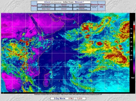
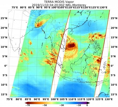
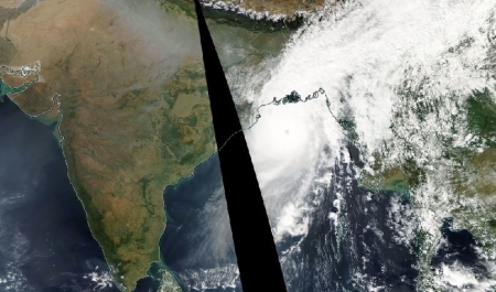
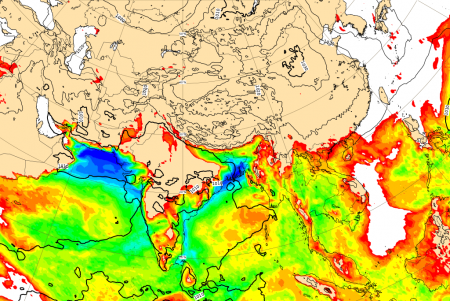
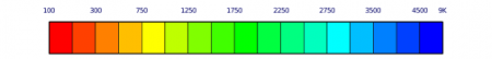
১) ইউরোপিয়ার মহাকাশ সংস্হা এর (EUMETSAT’s) Meteosat-7 নামক কৃত্রিম ভূ-উপগ্রহ ভারত মহাসাগর এর উপর অবস্হান করে প্রতিনিয়ত বায়ুমন্ডলে উপস্থিত জলিয় বাষ্প, মেঘ এর ছবি সংগ্রহ করছে যা দেখে ভারত মহাসাগর, বঙ্গপোসাগর ও আরব সাগরে ঘূর্ণিঝড়ের সম্ভব্য গতিপথের পূর্বাভাষ পাওয়া যায়। কৃত্রিম ভূ-উপগ্রহ থেকে প্রাপ্ত জলিয় বাষ্পের চিত্র। নীল-সবুজ-লাল কালার নির্দেশ করতে আর্দ্র বাতাস (যত বেশি লাল ও তত বেশি জলিয় বাষ্প)।
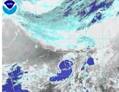
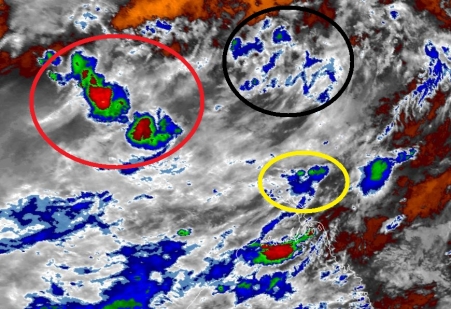
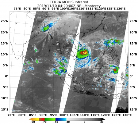
২) জাপানের কৃত্রিম ভূ-উপগ্রহ (আবহাওয়া উপগ্রহ) Himawari-8 দ্বারা সংগ্রহীত Shortwave Infrared চিত্র ও অনেক গুলো চিত্র নিয়ে তৈরি ভিডিও পাওয়া যায় ১৫ মিনিট অন্তর। আমেরিকার National Oceanic and Atmospheric Administration (NOAA) এর অংগ সংগঠন the National Environmental Satellite Data and Information Service (NESDIS) কর্তৃক পরিচালিত Office of Satellite and Product Operations (OSPO) থেকে। এই সাইটে বিভিন্ন কালারের ছবি পাওয়া যায়। খুবই উপকারি সাইট।
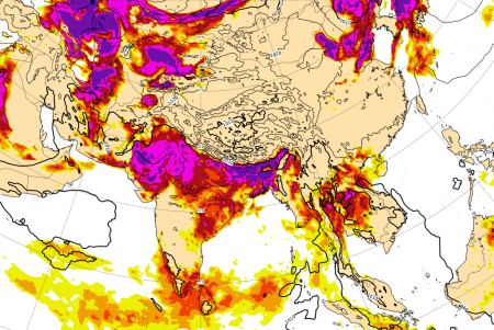
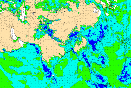
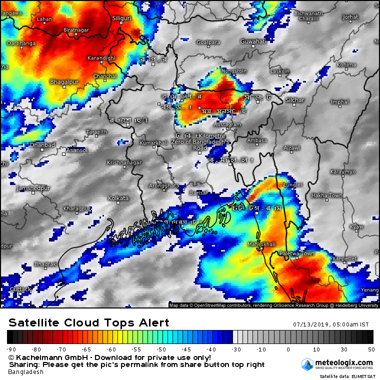
এই সাইট থেকে ১ নম্বর ছবির মতো রেইনবো কালারের ইনফ্রারেড ইমেজারি পাওয়া যায়। ১ নম্বর ছবিটি ইউরোপিয়ান ইউনিয়নের মেটিওরস্যাট-৮ নামক কৃত্রিম ভূ-উপগ্রহ থেকে পক্ষান্তরে ২ নম্বর ছবি জাপানের হিমাওয়ারি-৮ নামক কৃত্রিম ভূ-উপগ্রহ থেকে। দুইটি ছবির কাজ একই, ভারত মহাসাগরে ও তার চার পাশের দেশগুলোর স্হল ও জলভাগে কনভেকটি একটিভিটি মনিটরিং করা, যা দেখে সম্ভব্য ঘূর্ণিঝড় শুরুর অবস্থা নির্ণয় করা যায়।
[অতিরিক্ত তথ্য: Infrared satellite technology works by sensing the temperature of infrared radiation being emitted into space from the earth and its atmosphere. Basically, all objects (including water, land, and clouds), radiate infrared light. In general, the temperature of the atmosphere decreases with height. Since clouds are often high in the atmosphere (about 10,000 feet), they are in air that is much colder than the earth's surface. Therefore, the rule of thumb is: the brighter the cloud in an infrared image, the higher the cloud. Colder objects are brighter and warmer objects are darker.]
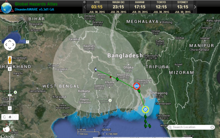
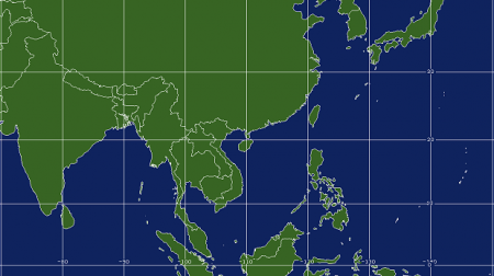
৩) আমেরিকার হাওয়াই রাজ্যে অবস্থিত Pacific Disaster Center কৃত্রিম ভূ-উপগ্রহ থেকে প্রাপ্ত তথ্য গানিতিক মডেলে ব্যবহার করে ঘূর্ণিঝড়ের সম্ভব্য গতিপথের পূর্বাভাষ দেয় প্রায় রিয়েল টাইম (প্রতি ঘণ্টায় আপডেট করে হয়)।
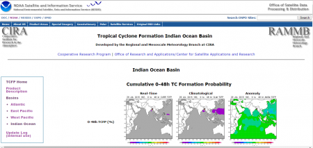
৪) Tropical Cyclone Formation Indian Ocean Basin (National Oceanic and Atmospheric Administration (NOAA)) সাইট থেকে নির্দিষ্ট করে ভারত মহাসাগর ও বঙ্গোপসাগরে সংঘটিত ঘূর্ণিঝড় এর রিয়েল টাইম পূর্বাভাষ পাওয়া যাবে ২ নম্বর লিংকে দেওয়া ওয়েবসাইট থেকে।
[৪ নম্বর ছবি]
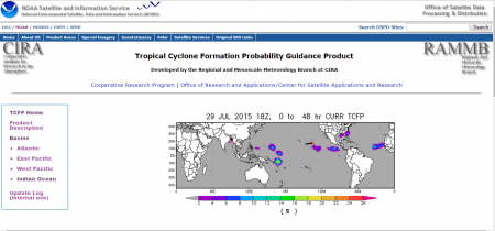
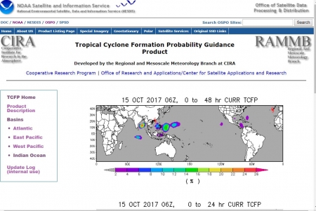
৫) Tropical Cyclone Formation Probability Guidance Product লিংকে দেওয়া ওয়েবসাইটটি ২ নম্বর লিংকে দেওয়া সাইটের পূর্নাঙ্গ রূপ যেখানে পৃথিবীর যে কোন স্থানের ঘূর্ণিঝড়, হ্যারিকেন, বা টাইফুন এর রিয়েল টাইম পূর্বাভাষ পাওয়া যাবে।
[৫ নম্বর ছবি]
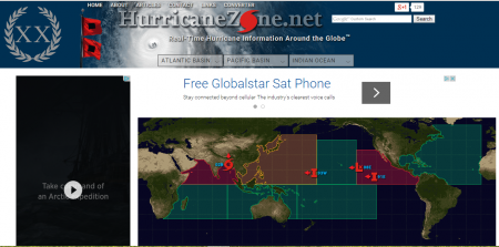
৬) Real-Time Hurricane Information Around the Globe নম্বর লিংকে দেওয়া ওয়েবসাইট হতেও পৃথিবীর যে কোন স্থানের ঘূর্ণিঝড়, হ্যারিকেন, টাইফুন এর রিয়েল টাইম পূর্বাভাষ পাওয়া যাবে।
[৬ নম্বর ছবি]
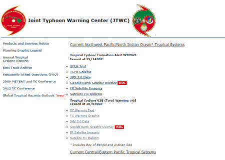
৭) আমেরিকার নৌবাহিনী কর্তৃক পরিচালিত ও প্রতিষ্ঠানটির নাম Joint Typhoon Warning Center (JTWC)
[৭ (ক) নম্বর ছবি]
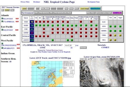
আমেরিকার নৌবাহিনী কর্তৃক পরিচালিত Naval Research Laboratory (NRL) Automated Tropical Cyclone Forecasting System Support Page ওয়েবসাইটে একই সাথে অনেক গুলো কৃত্রিম ভূ-উপগ্রহ থেকে পাওয়া চিত্র বিশ্লেষন করে Current Global Tropical Cyclone Activity পাওয়া যাবে। অধিকন্তু, বিভিন্ন লেভেলে বায়ুপ্রবাহ, তাপমাত্রা, চাপ, উইন্ড শিয়ার, বায়ুর ঘূর্ণন সম্পর্কিত মানচিত্র পাওয়া যাবে।
[৭ (খ) নম্বর ছবি]
ঘূর্ণিঝড় পূর্বাভাষের জন্য অন্যতম গুরুত্বপূর্ণ ভ্যারিয়েবল উইন্ড শিয়ার এর মানচিত্র পাওয়া যাবে যা থেকে ঘূর্ণিঝড়ের চারিত্রিক বৈশিষ্ট্য, প্রবাহের দিক, শক্তিমত্তা সম্বন্ধে তথ্য পাওয়া যাবে। এই সাইটি বুকমার্ক করে রাখা প্রত্যেক আবহাওয়া-বিদের জন্য অপরিহার্য বলে আমি মনে করি।
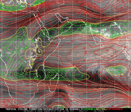
[৭ (গ) নম্বর ছবি]
University of Wisconsin-Madison বিশ্ববিদ্যালয়ের এর Cooperative Institute for Meteorological Satellite Studies এর সাইট থেকে বায়ুমন্ডলের বিভিন্ন উচ্চতায় বায়ু প্রবাহের দিক ও উইন্ড শিয়ার এর মানচিত্র পাওয়া যাবে যা দেখে কোন ঘুর্নিঝড় এর সাম্ভব্য গতিপথ সম্বন্ধে পূর্বাভাষ করা যাবে আবহাওয়া পূর্বাভাষ সম্পর্কিত জ্ঞান প্রয়োগ করে। একই সাথে পূর্বাভাষ করা যাবে ঘুর্নিঝড়ের গতিপথে এটি শক্তিশালী হবে না দূর্বল হবে। ঘুর্নিঝড়টির সাম্ভব্য গতিপথ আগামীতে পরিবর্তণ হওয়ার সম্ভাবনা।
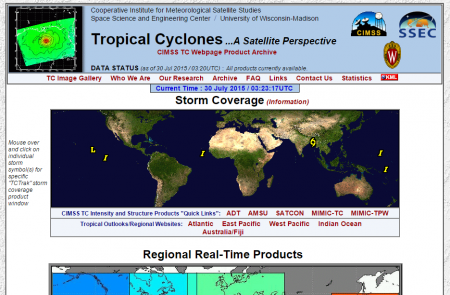
৮) আমেরিকার University of Wisconsin-Madison বিশ্ববিদ্যালয়ের এর Cooperative Institute for Meteorological Satellite Studies কর্তৃক পরিচালিত এই সাইট হতে বিভিন্ন কৃত্রিম ভূ-উপগ্রহ থেকে প্রাপ্ত ঘুর্ণিঝড়ের ছবি ও ভিডিও পাওয়া যাবে। শুধু তাই না; এই সাইটে কৃত্রিম ভূ-উপগ্রহ থেকে প্রাপ্ত ছবির বর্ণনা ও ঘুর্ণিঝড় সম্পর্কীত তথ্যও পাওয়া যাবে। এই সাইটি আমার অন্যতম প্রিয় তথ্যসুত্র।
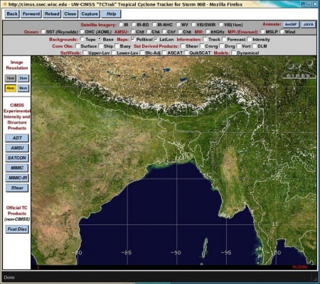
এই সাইটে চিহ্নিত কোন ঘূর্ণিঝড় সম্বন্ধে বিস্তারিত জানতে চাইলে সেই ঘূর্ণিঝড়টিকে সিলেক্ট করলে নিম্নলিখিত উইন্ডোটি ওপেন হবে। যেখান থেকে বিভিন্ন বিষয় সম্বন্ধে জানা যাবে। যেমন: ঘূর্ণিঝড়টির সম্ভব্য গতিপথ; ঘূর্ণিঝড়টি বর্তমানে যে স্থানে অবস্থান করছে সেই স্থানের বা ঘূর্ণিঝড় উৎপত্তিস্থলের বায়ুর গতিবেগ, সমুদ্রের পানির তাপমাত্রা, উইন্ড-শিয়ার ইত্যাদি।
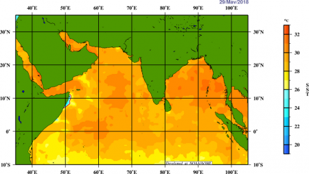
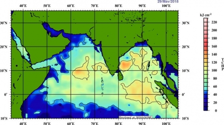
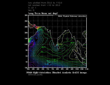
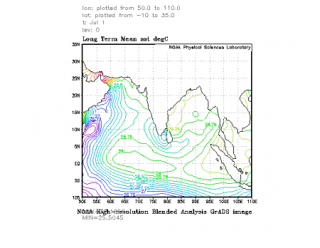
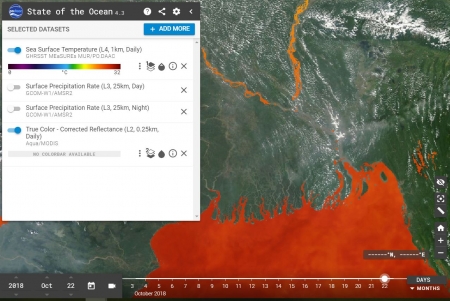
ঘূর্ণিঝড় সাম্ভভ্যতা বা ঘূর্ণিঝড়ের সাম্ভাভ্য পথের পূর্বাভাষের জন্য আবহাওয়াবিদরা অন্যতম নির্দেশক বা সহায়ক হিসাবে ব্যবহার করে থাকে সমুদ্র পৃষ্ঠের পানির তাপমাত্রাকে। সমুদ্রের কোন স্থানে ঘূর্ণিঝড় সৃষ্টি হওয়া ও বা সৃষ্ট ঘূর্ণিঝড়ের শক্তিশালী হওয়ার জন্য অন্যতম শর্ত হলও সমুদ্র পৃষ্ঠের পানির তাপমাত্রা সর্বনিম্ন ২৮ ডিগ্রী সেন্টিগ্রেড থাকা। কোন ঘূর্ণিঝড় উপকূলের দিকে অগ্রসর হওয়ার পরে শক্তিশালী হবে নাকি দুর্বল হবে তা সমুদ্র পৃষ্ঠের পানির তাপমাত্রা দেখে পূর্বাভাষ করা হয়ে থাকে। একই সাথে সমুদ্রের কোন স্থানের প্রথম ২০০ মিটার পানির তাপমাত্রা দেখে ঘূর্ণিঝড় সাম্ভভ্যতা পূর্বাভাষ করা হয়ে থাকে। আমেরিকার আবহাওয়া অধিদপ্তর পৃথিবীর বিভিন্ন সাগর ও মহাসাগরের সমুদ্র পৃষ্ঠের তাপমাত্রার মানচিত্র তৈরি করেছে যা নিম্নোক্ত ওয়েবসাইট থেকে সংগ্রহ করা যাবে।
Sea Surface Temperature, Sea Height Anomaly, and Tropical Cyclone Heat Potential map
NOAA/PhOD Ocean Observations Viewer V2.0
Current Operational Coral Bleaching 5km Daily Products
Tropical Cyclone Heat Potential (TCHP):
Tropical cyclones (known as hurricanes in the tropical Atlantic, western Pacific, and northern Indian oceans; as typhoons in the eastern Pacific Ocean; and as cyclones in the southern Pacific and Indian oceans) are characterized by very high waves and strong winds, that can be measured by altimeters. Altimetry data in combination with historical hydrographic observations are currently used to estimate synthetic upper ocean temperature profiles. These profiles are then used to compute the integrated vertical temperature from the sea surface down to the 26°C isotherm, the temperature needed to sustain a tropical cyclone. This quantity is usually referred to as the Hurricane or Tropical Cyclone Heat Potential (TCHP) and represents the amount of heat in the upper ocean available for tropical cyclone intensification.
Ocean Heat Content
IAP global ocean heat content gridded product at 1°×1° horizontal resolution
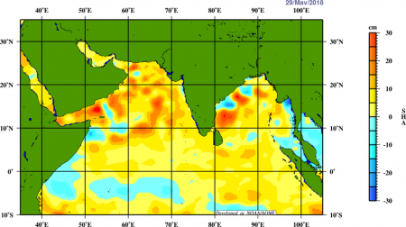
satellite altimetry can help identify the warm features that can cause tropical storms to intensify. Thus sea surface height anomalies can be used as proxies of the warm currents, that provide the tropical cyclones/hurricanes/ typhoons with their energy source.
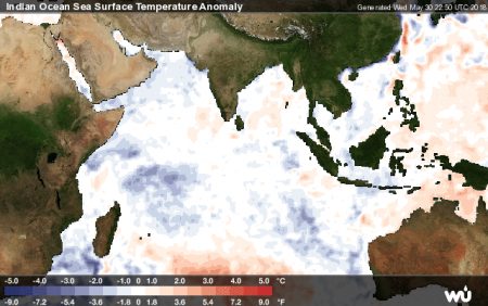
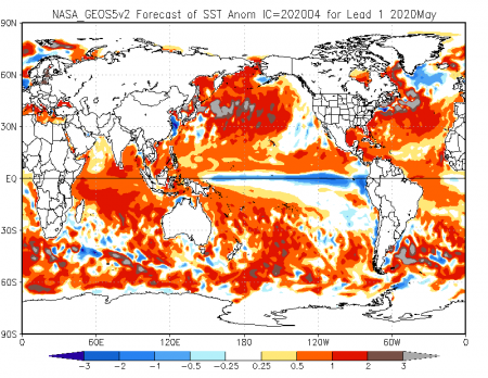
এছাড়াও Weather Underground ওয়েবসাইট থেকে বিভিন্ন সাগর ও মহাসাগর এর সমুদ্র পৃষ্ঠের তাপমাত্রা ও তাপমাত্রার বিচ্যুতির (Anomalies (i.e., the daily OISST minus a 30-year climatological mean) represent departures from "normal" or average conditions.) মানচিত্র পাওয়া যাবে।
নিম্নে অতিরিক্ত ৪ টি ওয়েবসাইটের লিংক যোগ করা হলও যে সাইগুলো থেকে সমুদ্র পৃষ্ঠের তাপমাত্রা বিষয়ক বিভিন্ন মানচিত্র পাওয়া যাবে যে মানচিত্র গুলো দেখে কোন স্থানের সম্ভব্য আব হাওয়া ও জলবায়ু সম্বন্ধে ধারণা পাওয়া যাবে।
Optimum Interpolation Sea Surface Temperature (OISST)
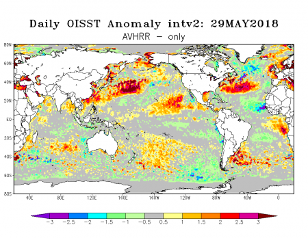
The NOAA 1/4° daily Optimum Interpolation Sea Surface Temperature (or daily OISST) is an analysis constructed by combining observations from different platforms (satellites, ships, buoys) on a regular global grid.
NOAA OI SST V2 High Resolution Dataset থেকে নিজের পছন্দের এলাকার সমুদ্রের পানির তাপমাত্রার মানচিত্র তৈরি করা যাবে নিচের চিত্রের মতো।
NOAA/NESDIS Sea Surface Temperature (SST) Charts
NOAA Climate Diagnostics Center SST Images
University of Wisconsin – Sea Surface Temperatures (SST)
Forecasts of Monthly Climate Anomalies and NMME Realtime Forecasts Archive
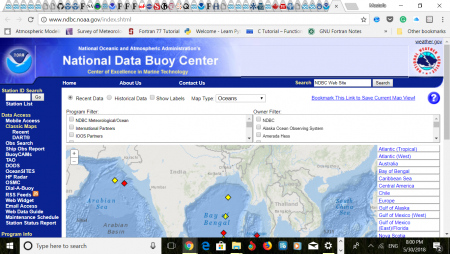
Where can I get real-time ship and buoy data?
সমুদ্রে নিম্নচাপ বা ঘূর্ণিঝড় সৃষ্টি হলে ঐ স্থানে সমুদ্রপৃষ্ঠের বায়ুর চাপ কমে যায়। ফলে ঐ স্থানের সমুদ্রপৃষ্ঠের পানির উচ্চতা বেড়ে যায়। একই ভাবে ঘূর্ণিঝড় যে পথে অগ্রসর হয় সেই পথে সমুদ্রপৃষ্ঠের পানির উচ্চতা বেড়ে যায়। এছাড়াও শক্তিশালী বায়ুপ্রবাহের ফলেও সমুদ্রপৃষ্ঠের পানির উচ্চতা বেড়ে যায়। ভূমিকম্পের ফলে সৃষ্ট সুনামির ফলেও সমুদ্রপৃষ্ঠের পানির উচ্চতা বেড়ে যায়। সমুদ্রপৃষ্ঠের পানির উচ্চতা বেড়ে যাওয়া পরিমাপ করা যায় দুই ভাবে। সরাসরি মাপা যায় জাহাজ থেকে অথবা সমুদ্র স্থাপিত ভাসমান স্থাপনা যেমন বয়ার মাধ্যমে। এছাড়াও কৃত্রিম ভূ-উপগ্রহে স্থাপিত আল্টিমিটার এর মাধ্যমে সমুদ্রপৃষ্ঠের পানির উচ্চতা পরিমাপ করা যায়। উপরে সংযুক্ত ওয়েবসাইট থেকে বয়ার মাধ্যমে সংগৃহীত সমুদ্র পৃষ্ঠের পানির উচ্চতা রিয়েল টাইম পর্যবেক্ষণ করা যায়। এই তথ্য খুবই গুরুত্বপূর্ণ। কারণ বয়ার মাধ্যমে সংগৃহীত তথ্য দেখে পূর্বাভাষ করা যায় সুনামি বা ঘূর্ণিঝড়ের ফলে উপকূলীয় এলাকায় কত ফুট উঁচু জলোচ্ছ্বাস সৃষ্টির সম্ভাবনা রয়েছে।
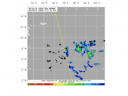
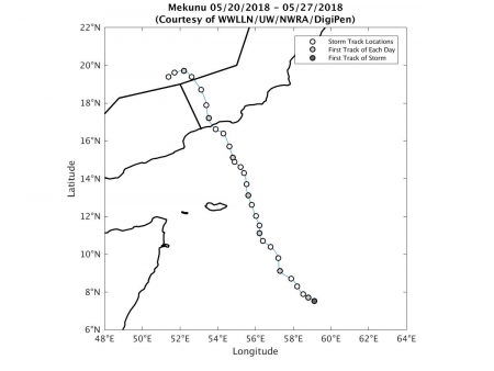
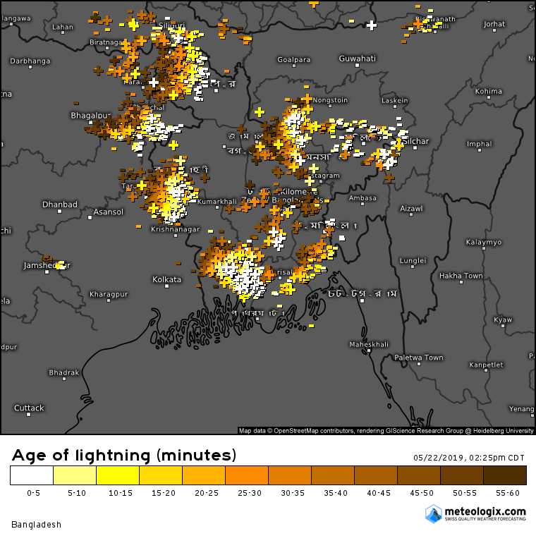
সমুদ্রে সৃষ্ট ঘূর্ণিঝড় সময়ের সাথে শক্তিশালী হচ্ছে নাকি দুর্বল হচ্ছে তা পর্যবেক্ষণের জন্য একটি নির্দেশক হচ্ছে ঘূর্ণিঝড় কেন্দ্রের ও আর চার পাশে অবস্থিত মেঘের মধ্যে বজ্র বিদ্যুৎ এর সংখ্যা পর্যবেক্ষণ করা। বজ্র বিদ্যুৎ এর সংখ্যা বৃদ্ধি ঘূর্ণিঝড় এর শক্তিশালী হওয়া নির্দেশ করে; পক্ষান্তরে বজ্র বিদ্যুৎ এর সংখ্যা কমে যাওয়া আপাত ভাবে ঘূর্ণিঝড় দুর্বল হয়ে যাওয়া নির্দেশ করে।
The World Wide Lightning Location Network (WWLLN) team, a group coordinated by the University of Washington in Seattle, operates a network of lightning location sensors that produces regular maps of lightning activity all over the world. To tackle the demand for continuous tropical cyclone monitoring, the WWLLN team has developed a unique “storm-following” tool and a public website known as WWLLN Tropical Cyclones। The website visualizes lightning data in near-real time for all tropical cyclones across the globe.
Visualization of WWLLN lightning and passive microwave satellite data for tropical cyclones globally updated every 3 hours. WWLLN Tropical Cyclones সাইট থেকে নিম্নোক্ত তথ্য গুলো পাওয়া যাবে: Storm Track Map; Lightning Histogram Plot; Lightning Density Plot; GMI 89 GHz PCT Satellite Overlay; SSMIS 91 GHz PCT Satellite Overlay। WWLLN-TC provided a way to monitor the storm’s intensity and precipitation continuously। The WWLLN-TC website collects all data in near-real time. An archive of all of the more than 700 tropical cyclones that have occurred since November 2009 is also available to those who visit the site.
৯) আমেরিকার National Oceanic and Atmospheric Administration (NOAA) কর্তৃক পরিচালিত কিন্তু তারা জাপানের আবহাওয়া উপগ্রহ Himawari-8 থেকে চিত্র সংগ্রহ করে।
Regional and Mesoscale Meteorology Branch SLIDER provides full-resolution, standard and value-added imagery products from GOES-16 and Himawari-8 to both the scientific community and the general public.
(The Infrared satellite image (৯ (খ) নম্বর ছবি) is taken by Japan's Space Agency's Himawari-8 satellite using a wavelength (Band 10 (7.3 µm)) sensitive to the content of water vapor in the atmosphere. Bright and colored areas indicate high water vapor (moisture) content (colored and white areas indicate the presence of both high moisture content and/or ice crystals))
The GOES-13 weather satellite has been renamed EWS-G1 (Electro-optical Infrared Weather System Geostationary) and now provides coverage over the Indian Ocean for the military. After more than seven years as NOAA’s GOES East satellite, GOES-13 was retired in January 2018 to make way for GOES-16. Check out the "blast-from-the-past" 5 spectral bands as compared to the 16 ABI bands we enjoy from GOES-16.
Click This Link target='_blank' >আমেরিকার আবহাওয়া পূর্বাভাষ সংস্হা NOAA’s এর অবসরপ্রাপ্ত GOES East satellite GOES-13 বর্তমানে ভারত মাহাসাগর এর উপর অবস্হান করে আমেরিকান নৌবাহিনীর জন্য ৬ টি ব্যান্ডে ভূপৃষ্ঠ চিত্র প্রদান করছে। এই কৃত্রিম উপগ্রহ থেকে প্রতি ৩০ মিনিট পর-পর একটি করে চিত্র পাওয়া যাবে। এই চিত্র ও জাপানের কৃত্রিম ভূ-উপগ্রহ থেকে প্রাপ্ত চিত্র ও ইউরোপিয়ান ইউনিয়নে কৃত্রিম ভূ-উপগ্রহ থেকে প্রাপ্ত চিত্র একত্রিত করে প্রায় নিয়ার রিয়েল টাইম ঘূর্ণিঝড় ও বৃষ্টিপাতের চিত্র পাওয়া যাবে ভারত, পাকিস্তান ও বাংলাদেশের স্থল ও ভারত মহাসাগর ও বঙ্গোপসাগরের উপর।
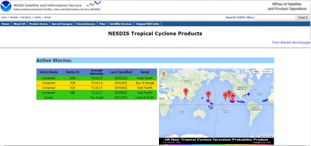
১০) আমেরিকার National Oceanic and Atmospheric Administration (NOAA) কর্তৃক পরিচালিত Tropical Cyclone Formation Probability Guidance Product Developed by the Regional and Mesoscale Meteorology Branch at CIRA/ NESDIS Tropical Cyclone Products হতে পৃথিবীর যে কোন প্রান্তে সৃষ্ট ঘূর্ণিঝড়, টাইফুন, হ্যারিকেন এর চলমান আপডেট পাওয়া যাবে
NESDIS Tropical Cyclone ওয়েবসাইটটি উপরে ১০ নম্বর লিংকে দেওয়া সাইটের বিশেষ রূপ: যেখানে শুধুমাত্র বঙ্গোপসাগরে সৃষ্ট ঘূর্ণিঝড় এর চলমান আপডেট পাওয়া যাবে)
[১০ (খ) নম্বর ছবি]
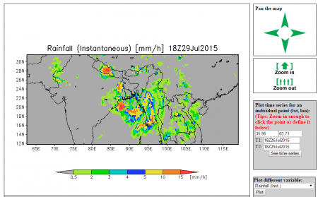
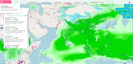
১১) আমেরিকার আমেরিকার University of Maryland এর Global Flood Monitoring System ওয়েবসাইট (১১ নম্বর লিংক) হতে সারা বিশ্বের বৃষ্টিপাত, বন্যা, নদীর প্রবাহ এর চিত্র পাওয়া যাবে (বর্তমান সময়ের ৩ ঘণ্টা পূর্ব পর্যন্ত; অর্থাৎ, দুপুর ১২ টায় পাওয়া যাবে সকাল ৯ টা পর্যন্ত বৃষ্টিপাত এর চিত্র)। এখানে উল্লেখ্য যে বর্তমানে বিশ্বের সবচেয়ে নিখুঁত কৃত্রিম উপগ্রহ হলো Global Precipitation Measurement (GPM) ।
[১১ নম্বর ছবি]
১২) Near-Realtime Integrated Multi-satellite REtrievals for GPM (IMERG) Early Run Half-Hourly Image প্রতি ৩০ মিনিট অন্তর সারাবিশ্বের বৃষ্টিপাতের চিত্র পাওয়া যাবে। এই চিত্র তৈরি করা হয় অনেক গুলো কৃত্রিম উপগ্রহ হতে সংগৃহীত চিত্র ব্যবহার করে। তাই এই চিত্র গুলোর নামকরণ করা হয়েছে Integrated Multi-satellite REtrievals for GPM (IMERG) Early Run Half-Hourly Image হিসাবে।
[১২ (ক) নম্বর ছবি]
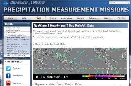
Precipitation Measurement Mission ওয়েবসাইট থেকে Global Precipitation Measurement (GPM) mission এর একাধিক কৃত্রিম ভূ-উপগ্রহ থেকে প্রাপ্ত তথ্য দ্বারা তৈরিকৃত বৃষ্টিপাতের Real-time 3 Hourly and 7 Day Rainfall এর মানচিত্র পাওয়া যাবে।
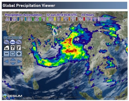
আমেরিকার মহাকাশ গবেষণা সংস্থা নাসা এর Cesium viewer পোর্টাল থেকে বৃষ্টিপাতের নিয়ার রিয়েল টাইম মানচিত্র পাওয়া যাবে। মানচিত্রের উপর জুম করে দেখা যাবে নির্দিষ্ট কোন এলাকায় গত ৩০ মিনিট থেকে গত ৭ দিনের সর্বমোট বৃষ্টিপাতের পরিমান।Cesium viewer shows realtime precipitation estimates from the GPM IMERG product
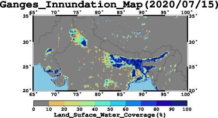
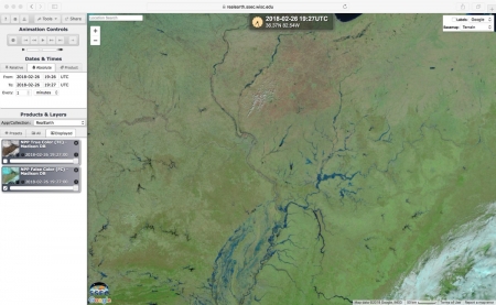
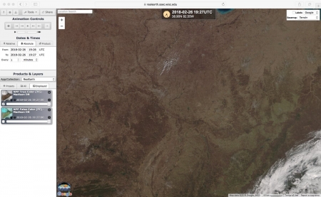
১৩) Near Real-Time Global MODIS Flood Mapping থেকে খুবই উচ্চ রেজুলেশনে (২৫০ মিটার বাই ২৫০ মিটার) বন্যার চিত্র পাওয়া যাবে নিচের ১৩ নম্বর সাইট হতে। এই সাইটি পরিচালিত হয়ে থাকে আমেরিকার মহাকাশ গবেষনা সংস্হা থেকে।
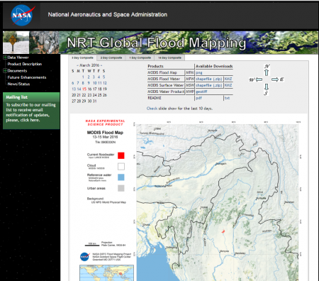
[১৩ নম্বর ছবি]
জাপানের টোকিও বিশ্ববিদ্যালয়ের Institute of Industrial Science ডিপার্টমেন্টের সহযোগিতায় Satellite-based flood monitoring and early warning system (S-FMEWS) এর মাধ্যমে বিশ্বের বিভিন্ন নদী অববাহিকার প্রায় রিয়েল টাইম বন্যা প্লাবিত এলাকার মানচিত্র পাওয়া যায়।
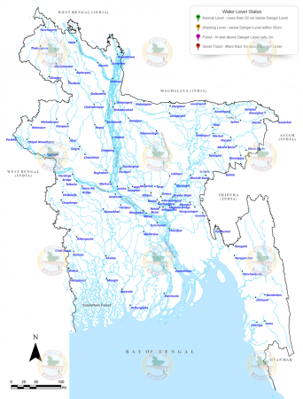
বাংলাদেশ পানি উন্নয়ন বোর্ডের চলমান বন্যা প্লাবিত এলাকার মানচিত্র পাওয়া যায় Feedback Flood Forecasting & Warning Centre
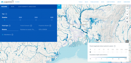
The Aqueduct Global Flood Analyzer is a web-based interactive platform that measures river flood impacts by urban damage, affected GDP, and affected population at the country, state, and river basin scale across the globe.
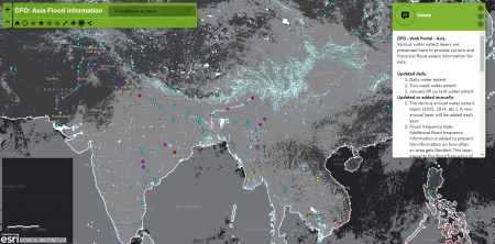
DFO Asia Flood Information
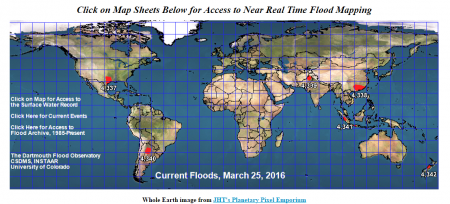
১৪) আমেরিকার নিউ হ্যাম্পশায়ার রাজ্যে অবস্হিত বিশ্ব বিখ্যাত শিক্ষা প্রতিষ্ঠান Dartmouth College (নামে যদিও কলেজ লিখা আছে তবে এটি একটি পূর্নাঙ্গ বিশ্ববিদ্যালয়) এর Near Real Time Flood Mapping from Dartmouth Flood Observatory থেকে সারা বিশ্বের চলমান বন্যার মানচিত্র পাওয়া যাবে এই সাইট থেকে। এই সাইট টি বর্তমানে University of Colorado পরিচালনা করে থাকে। এই সাথে একই সাথে অনেক গুলো তথ্য পাওয়া যাবে যেমন: টেরা ও একুয়া নামক ২টি কৃত্রিম উপগ্রহ (স্যাটেলাইট) থেকে প্রাপ্ত চিত্র দেখে নির্ণয় করা যাবে আকাশে মেঘের অবস্থান ও তার প্রবাহের দিক। এছাড়াও পাওয়া যাবে কোন স্থানে সর্বশেষ ৭ দিনের সর্বমোট বৃষ্টিপাতের পরিমাণ (7-day Accumulated Rainfall)। পাওয়া যাবে বড়-বড় নদীতে কি পরিমাণ পানি প্রবাহিত হচ্ছে তার তথ্য যা দেখে নির্ধারণ করা যাবে কোন স্থানের মানুষ কতটুকু নিরাপদ। এই ওয়েবসাইট থেকে ১৯৮৫ সালের পর থেকে সারা বিশ্বে বড়-বড় যে বন্যা গুলো হয়েছে তার পরিসংখ্যান পাওয়া যাবে। বন্যার যে মানচিত্র পাওয়া যাবে এই সাইটে তা সর্বশেষ ১৪ দিনের ভূ-উপগ্রহ হতে প্রাপ্ত চিত্র হতে তৈরি করা হয়। টেরা ও একুয়া নামক কৃত্রিম উপগ্রহ (স্যাটেলাইট) দুটি প্রতি ২৪ ঘন্টায় প্রথিবী পৃষ্ঠের নির্দিষ্ঠ কোন স্হানের উপর দিয়ে অতিক্রম করে থাকে ও ঐ স্হানের ছবি তুলে থাকে।
[১৪ নম্বর ছবি]
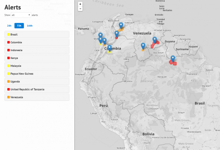
১৫) Extreme Rainfall Detection System (ERDS) পোর্টাল থেকে রিয়েল টাইম সারা বিশ্বের বিভিন্ন স্হানের আগামী ২৪ ঘন্টা (১ দিন), ৭২ ঘন্টা (৩ দিন) ও ১৪৪ ঘন্টা (৬ দিন) এর বন্যার পূর্বাভাষ পাওয়া যাবে। একই সাথে নির্দিষ্ঠ বন্যার ফলে ঐ এলাকায় কি পরিমান মানুষ ক্ষতিগ্রস্ত হবে সেই সংখ্যাও পাওয়া যাবে। আর একটি তথ্য পাওয়া যাবে এই পোর্টাল থেকে তা হলো ঐ সকল স্হানে সাম্ভাব্য মোট বৃষ্টিপাতের পরিমান। কোন স্হানে কোন ধরনের বন্যা হবে (সাধারণ, মধ্যম ও প্রচন্ড) তা ৩ টি কালারের মাধ্যমে নির্দেষ করা হয়ে থাকে। এই পোর্টালটি ইতালির Information Technology for Humanitarian Assistance, Cooperation and Action (সংক্ষেপে ITHACA) নামক একটি সংস্হা পরিচালনা করে থাকে। UN World Food Programme (WFP) এই পোর্টালের তথ্য ব্যবহার করে পৃথিবীর বিভিন্ন স্হানে অতি বৃষ্টি ও বন্যার ফলে ক্ষতিগ্রস্ত মানুষদের মধ্যে রিলিফ বিতরণ করে থাকে।
[১৫ নম্বর ছবি]
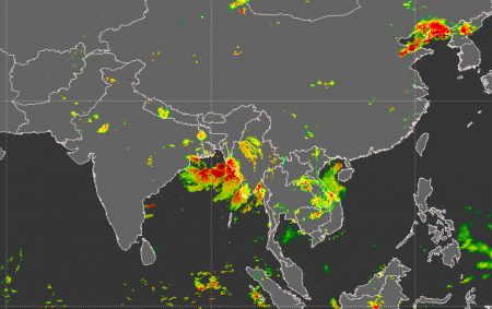
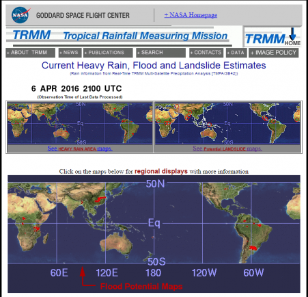
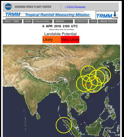
১৬)The Tropical Rainfall Measuring Mission (TRMM) এর Current Heavy Rain, Flood and Landslide Estimates সাইট হতে চলমান বৃষ্টিপাত, বন্যায় আক্রান্ত এলাকা ও অতিবৃষ্টির কারণে ভূমিধ্বস এর সাম্ভাবনা আছে এমন এলাকার মানচিত্র পাওয়া যাবে।
[১৬ নম্বর ছবি]
১৭) আমরা সকলেই জানি ঘূর্ণিঝড়ের সময় প্রচুর পরিমাণে বৃষ্টি হয়। আর অতিবৃষ্টি ভূমিধ্বসের অন্যতম প্রধান কারণ। ১৭ নম্বর লিংকে দেওয়া ওয়েবসাইট হতে প্রায় রিয়েল টাইম ভূমিধ্বস পূর্বাভাষ পাওয়া যায়। এই ওয়েব সাইটটিও আমেরিকার National Oceanic and Atmospheric Administration (NOAA) কর্তৃক পরিচালিত রিয়েল টাইম ভূমিধ্বস পূর্বাভাষ: Near Real Time Landslide Potential in Google Earth
[১৭ নম্বর ছবি]
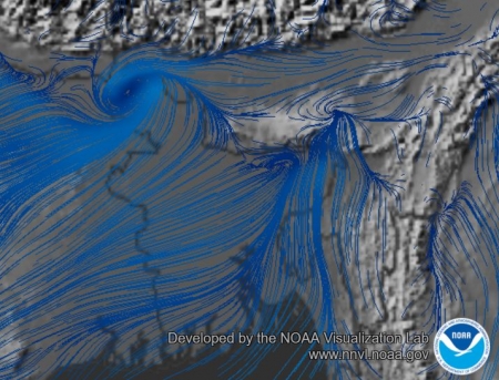
১৮) National Oceanic and Atmospheric Administration (NOAA) কর্তৃক পরিচালিত Color-enhanced Global Winds Visualization সাইট থেকে রিয়েল টাইম বায়ু প্রবাহের দিক সম্বন্ধে চিত্র পাওয়া যাবে। বায়ু প্রবাহের দিক দেখে ধারনা পাওয়া যাবে ঘূর্ণিঝড় এর সাম্ভব্য পথ, অর্থাৎ কোন দিকে প্রবাহিত হবে।বায়ু প্রবাহ ছাড়াও এই সাইট থেকে পৃথিবীর যে কোন স্হানের ভূ-পৃষ্ঠের তাপমাত্রা, বায়ুতে জ্বলিয়বাষ্পের পরিমান, বৃষ্টিপাত, বায়ু চাপ এর তথ্য পাওয়া যাবে। এই তথ্য গুলো ব্যবহার করে কোন স্হানের দৈনন্দিন আবহাওয়া সম্বন্ধে সাম্যক ধারণা পাওয়া যাবে।
[১৮ নম্বর ছবি]
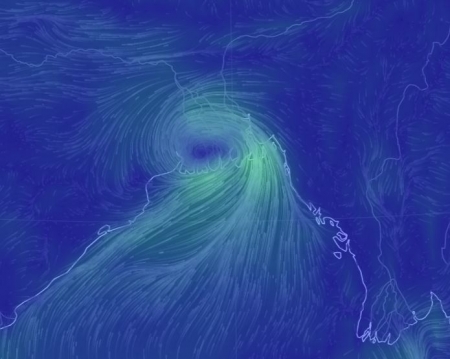
১৯) Earth Null School সাইট থেকেও রিয়েল টাইম বায়ু প্রবাহের দিক সম্বন্ধে চিত্র পাওয়া যাবে। বায়ু প্রবাহের দিক দেখে ধারনা পাওয়া যাবে ঘূর্ণিঝড় এর সাম্ভব্য পথ, অর্থাৎ কোন দিকে প্রবাহিত হবে। উপরের ১৮ নম্বর সাইটের চেয়ে এই সাইটি বেশি দ্রুত। "Using supercomputers, Earth Null School forecasts these weather patterns updating the weather map every 3 hours. While weather is based on NOAA’s global forecast system, oceans currents are based on OSCAR’s."
[১৯ নম্বর ছবি]
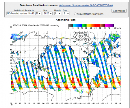
NRT Ocean Surface Winds Data from Satellite/Instruments সাইট থেকেও রিয়েল টাইম বায়ু প্রবাহের দিক (সমুদ্র পৃষ্ঠের উপর) সম্বন্ধে চিত্র পাওয়া যাবে।
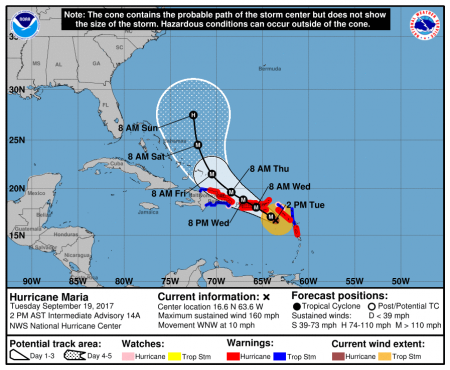
২০) আমেরিকার National Oceanic and Atmospheric Administration পরিচালিত National Hurricane Center সাইট হলও আমেরিকার অফিসিয়াল প্রতিষ্ঠান যা হ্যারিকেন এর পূর্বাভাষ ও চলার পথের তথ্য ইস্যু করে।
[২০ নম্বর ছবি]
"National Hurricane Center forecast synthesizes all of the available information. Its most widely known report is the official five-day forecast, which shows the projected path of the storm’s center of circulation and the surrounding “cone of uncertainty."
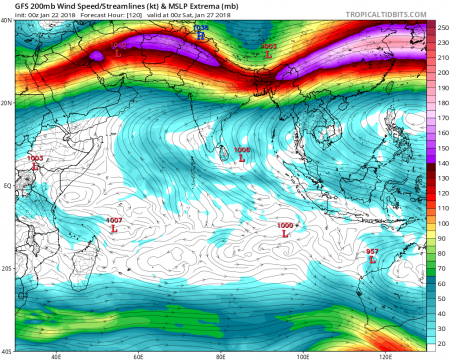
২১) Operational Numerical Weather Prediction: Tropical Tidbits
[২১ নম্বর ছবি]
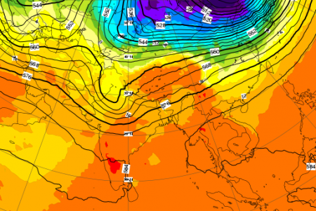
২২) 500 hPa geopotential height (contours) and temperature at 850 hPa (shading) from the ECMWF HRES model.
[২২ নম্বর ছবি]
২৩) Seasonal Climate Forecast from Columbia University's International Research Institute (IRI) for Climate and Society:
[২৩ নম্বর ছবি]
২৪) Probabilistic temperature/precipitation seasonal forecasts from multi-model ensembles through the use of statistical recalibration, based on the historical performance of those models
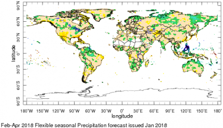
[২৪ নম্বর ছবি]
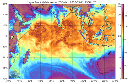
Morphed Integrated Microwave Imagery at CIMSS - Total Precipitable Water সাইট থেকে নিয়ার রিয়েল টাইম দেখা যাবে পৃথিবী পৃষ্ঠের উপরের বায়ুমণ্ডলে (ট্রপোসফেয়ারে) কোন স্থানে বৃষ্টি হওয়ার মতো কি পরিমাণ জ্বলিয় বাষ্প উপস্থিত রয়েছে। এই তথ্য দেখে পূর্বাভাষ করে যাবে কোন স্থানে কি পরিমাণ বৃষ্টি হওয়ার সম্ভাবনা রয়েছে। একাধিক কৃত্রিম উপগ্রহ থেকে তথ্য নিয়ে ও গাণিতিক মডেল ব্যবহার করে এই চিত্র তৈরি করা হয়েছে। এই সাইট থেকে বায়ুমণ্ডলের বিভিন্ন উচ্চতায় (যেমন ৮৫০ মিলিবার, ৫০০ মিলিবার ইত্যাদি) কি পরিমাণ জ্বলিয় বাষ্প উপস্থিত সেই মানচিত্রও পাওয়া যাবে।
[Precipitable water (PW) is a measure of the depth of liquid water at the surface that would result after precipitating all of the water vapor in a vertical column over a given location, usually extending from the surface to 300 mb. PW values of 0.50" (13 mm) of less is considered very dry while values of 2" (50 mm) or greater is very moist. ]
ঘূর্ণিঝড়ের জীবনচক্র সম্বন্ধে সর্বাপেক্ষা বেশি তথ্য পাওয়া যায় কৃত্রিম উপগ্রহ থেকে প্রাপ্ত ৮৫-৯১ গিগাহার্জ এর মাইক্রোওয়েভ তরঙ্গের চিত্র থেকে। কিন্তু সমস্যা হলও পোলার ওর্বিটিং স্যাটেলাইট ভূ-পৃষ্ঠের কোন স্থানের উপর একটি নির্দিষ্ট সময় পর-পর ভ্রমণ করে ঐ স্থানের বায়ুমণ্ডলের বিভিন্ন তথ্য সংগ্রহ করে থাকে। ফলে দুইটি চিত্রের মধ্যবর্তী সময়ে ঘূর্ণিঝড়ের জীবনচক্র সম্বন্ধে কোন তথ্য পাওয়া যায় না পোলার ওর্বিটিং স্যাটেলাইট। ঘূর্ণিঝড় যতক্ষণ পর্যন্ত না কোন রাডার এর সীমার মধ্যে আসে ততক্ষণ পর্যন্ত নিরবিচ্ছিন্ণ তথ্য পাওয়া যায় না। প্রায় সময় ঘূর্ণিঝড় যতক্ষণে উপকূলীয় এলাকায় অবস্থিত রাডার এর সীমার মধ্যে চলে আসতে ততোক্ষণে দুর্যোগ ব্যবস্থাপনার জন্য পর্যাপ্ত সময় পাওয়া যায় না প্রায় সময় কারণ অনেক সময় ঘূর্ণিঝড় খুব অল্প সময়ের মধ্যে শক্তিশালী হয়ে উঠে। উপরোক্ত সমস্যা থেকে উত্তরণের জন্য আমেরিকার উইসকনসিন বিশ্ববিদ্যালয়ের বৈজ্ঞানিকরা একটি অ্যালগরিদম বানিয়েছেন যা দিয়ে একাধিক কৃত্রিম উপগ্রহ থেকে প্রাপ্ত ৮৫-৯১ গিগাহার্জ এর মাইক্রোওয়েভ তরঙ্গ ব্যাবহার ঠিক রাডারের অনুরপ নিরবচ্ছিন্ন কম্পিউটার সিমুলেশন তৈরি করা হয়। তবে তথ্যের সাইজ অনেক বড় হওয়ার প্রতি ১৫ মিনিট অন্তর একটি করে সিমুলেশন সংরক্ষণ করা হয়। সাইট থেকে বিশ্বের যে কোন প্রান্তে চলমান ঘূর্ণিঝড় এর জীবনচক্র পর্যবেক্ষণ করা যাবে প্রতিনিয়ত (নিয়ার রিয়েল টাইম)।
Morphed Integrated Microwave Imagery at CIMSS (MIMIC-TC)
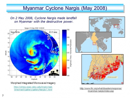
উপরে উল্লেখিত অ্যালগরিদম এর বিস্তারিত জানা যাবে "MIMIC: A New Approach to Visualizing Satellite Microwave Imagery of Tropical Cyclones" নামক বৈজ্ঞানিক প্রবন্ধ থেকে। এই বৈজ্ঞানিক প্রবন্ধের আ্যাবসট্রাক্ট তুলে দেওয়া হলো পাঠকদের সুবিধার্থে।
"Satellite-based passive microwave imagery of tropical cyclones (TCs) is an invaluable resource for assessing the organization and evolution of convective structures in TCs when often no other comparable observations exist. However, the current constellation of low-Earth-orbiting environmental satellites that can effectively image TCs in the microwave range make only semirandom passes over TC targets, roughly every 3-6 h, but vary from less than 30 min to more than 25 h between passes. These irregular time gaps hamper the ability of analysts/forecasters to easily incorporate these data into a diagnosis of the state of the TC. To address this issue, we have developed a family of algorithms called Morphed Integrated Microwave Imagery at the Cooperative Institute for Meteorological Satellite Studies (MIMIC) to create synthetic "morphed" images that utilize the observed imagery to fill in the time gaps and present time-continuous animations of tropical cyclones and their environment. MIMIC-TC is a product that presents a storm-centered 15-min-resolution animation of microwave imagery in the ice-scattering range (85-92 GHz), which can be interpreted very much like a ground-based radar animation. A second product, MIMIC-IR, animates a tropical cyclone-retrieved precipitation field layered over geostationary infrared imagery. These tools allow forecasters and analysts to use microwave imagery to follow trends in a tropical cyclone's structure more efficiently and effectively, which can result in higher-confidence short-term intensity forecasts."
========================
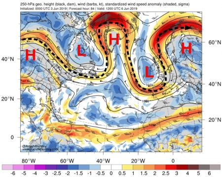
500 hPa Geopotential Height
=======================
The geopotential height of the 500 hPa pressure surface shows approximately how far one has to go up in the atmosphere before the pressure drops to 500 hPa (i.e. 500 millibars). On average this level is around 5.5 km above sea level, and it is often referred to as a steering level, because the weather systems beneath, near to the Earth's surface, roughly move in the same direction as the winds at the 500 hPa level. Height contours are labelled in tens of meters (=decametres, ="dam") with an interval of 4 dam. The contours effectively show the main tropospheric waves that "control" our weather - low heights indicate troughs and cyclones in the middle troposphere whilst high heights indicate ridges and anticyclones.
===================
850 hPa Temperature
===================
Colour shading indicates temperature at the 850 hPa level in degrees Celsius (oC), in 4oC colour bands. This is the temperature approximately 1.5 km above sea level, usually just above the boundary layer. At this level the diurnal (daily) cycle in temperature is generally negligible. Therefore temperature at 850 hPa can be used to indicate frontal zones (i.e. areas of the large temperature gradient, where the isotherms are more closely packed together), and naturally also to distinguish between warm and cold air masses. Sometimes temperature at 850 hPa can be used to roughly assess the maximum temperature at sea level by adding 10 to 15oC, and for higher ground one can interpolate. However, there are situations when this method does not apply, particularly in winter.
Upper air charts at various levels from ECMWF
********** Ensemble forecasts explained **************
One 'ensemble forecast' consists of multiple separate forecasts (in the case of the European Centre for Medium-Range Weather Forecasts (ECMWF) it is 51, for the Global Ensemble Forecast System (GEFS), previously known as the GFS Global ENSemble (GENS), is a weather forecast model made up of 21) made by the same computer model, all activated from the same starting time. The starting conditions for each member of the ensemble are slightly different, and physical parameter values used also differ slightly. The differences between these ensemble members tend to grow as the forecasts progress, that is as the forecast lead time increases.
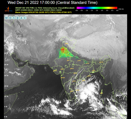
২৫) ইউরোপিয়ান মহাকাশ সংস্থা (EUMETSAT’s) এর Meteosat নামক কৃত্রিম ভূ-উপগ্রহ ভারত মহাসাগর এর উপর অবস্থান করে প্রতিনিয়ত এই অঞ্চলের দেশ গুলোর বায়ুমণ্ডলে উপস্থিত জলিয় বাষ্প, মেঘ, বায়ুপ্রবাহ, বৃষ্টিপাত, ফরেস্ট ফায়ার, ধুলো, কুয়াশা, স্নো, ডাস্ট, এর ছবি সংগ্রহ করে।
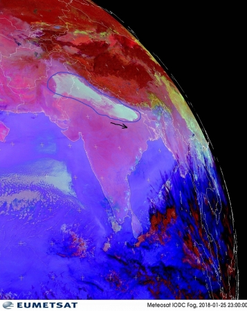
INSAT-3D ভারতীয় আবহাওয়া অধিদপ্তরের একটি বহুমুখী ব্যবহারযোগ্য কৃত্রিম ভূ-উপগ্রহ। এই কৃত্রিম ভূ-উপগ্রহটি ভারত মহাসাগরের উপরে বিষুবরেখা (Equator) বরাবর ৩৫ হাজার ৭৮৬ কিলোমিটার উপরে জিয়োসিনক্রোনাস কক্ষপথে অবস্থান করে ভারতীয় উপমহাদেশের উপরের আকাশে দৃষ্টি রাখছে। এই এই কৃত্রিম ভূ-উপগ্রহটির ওজন প্রায় ২ হাজার কিলোগ্রাম যার মধ্যে আবহাওয়া সম্পর্কিত যন্ত্রপাতির ওজন মাত্র প্রায় ১০০ কেজি। এই ভূ-উপগ্রহটিতে মোট ৬ টি চ্যানেল রয়েছে যার ১ টি চ্যানেল হলও দৃশ্যমান (VISIBLE) ও ৫ টি ইনফ্রারেড (আবলোহিত তরঙ্গ) চ্যানেল। দৃশ্যমান (visible) চ্যানেল থেকে ১ কিলোমিটার রেজুলেশনে চিত্র ও ইনফ্রারেড (আবলোহিত তরঙ্গ) চ্যানেল থেকে ৪ কিলোমিটার রেজুলেশনে ইনফ্রারেড চিত্র পাওয়া যায় প্রতি ৩ ঘণ্টা অন্তর-অন্তর। এই ভূ-উপগ্রহে একটি ইমেজার ও একটি সাউন্ডার সেন্সর রয়েছে। সাউন্ডার সেন্সরের মাধ্যমে বায়ুমণ্ডলের তাপমাত্রা ও আর্দ্রতার উ-লম্ব চিত্র তৈরি করা যায়। এই চিত্র থেকে বাংলাদেশ ও ভারতের আকাশের কুয়াশার রিয়েল টাইম চিত্র পাওয়া যায়। একই ভাবে বঙ্গোপসাগরে অবস্থিত ঘূর্ণিঝড় এর ত্রিমাত্রিক চিত্র পাওয়া যায়। INSAT-3D ভূ-উপগ্রহ সম্বন্ধে কারিগরি তথ্য পাওয়া যাবে Meteorological & Oceanographic Satellite Data Archival Centre এর ওয়েবসাইট থেকে।
আবহাওয়া পূর্বাভাস মডেল হতে প্রাপ্ত তথ্য ব্যবহার করে কুয়াশা সৃষ্টির সম্ভাবনা মানচিত্র তৈরি করা যায় যা দেখে কোন স্থানে কি পরিমাণ কুয়াশা সৃষ্টির হতে পারে তার পূর্বাভাস করা যায়। কুয়াশা নির্দেশক এই সূচকটিকে Fog Stability Index না অবিহিত করা হয়। এই সূচক তৈরি করার জন্য ব্যবহার কার হয় ভূ-পৃষ্ঠ সংলগ্ন বায়ুর তাপমাত্রা, ডিউ-পয়েন্ট তাপমাত্রা, ৮৫০ মিলিবার উচ্চতায় বায়ুর তাপমাত্রা, ডিউ-পয়েন্ট তাপমাত্রা, ও বায়ুর গতিবেগ। এই সূচক এর মান যত কম হবে কুয়াশার ঘনত্ব তত বেশি হওয়ার সম্ভাবনা থাকবে।
আমেরিকার আবহাওয়া অধিদপ্তরের ওয়েবসাইটের Wind Chill Calculator এর মাধ্যমে অনুভূত তাপমাত্রা পরিমাপ করা যাবে।
২৬) বর্তমানে বিশ্বের সবচেয়ে নির্ভুল ও শক্তিশালী কৃত্রিম ভূ-উপগ্রহটির নাম হলো Geostationary Operational Environmental Satellite system 16 যা সংক্ষেপে GOES-16 নামে পরিচিত। এই কৃত্রিম ভূ-উপগ্রহটি আমেরিকার National Oceanic and Atmospheric Administration (NOAA) কর্তৃক পরিচালিত। এই কৃত্রিম ভূ-উপগ্রহটি সমুদ্র পৃষ্ঠ থেকে প্রায় ৩৬ হাজার কিলোমিটার উপরে অবস্থান করে পৃথিবীর পশ্চিম গোলার্ধের ছবি তুলে পৃথিবীতে অবস্থিত তথ্য সংগ্রহ স্টেশনে পাঠায়। A brief overview of the new GOES-16 satellite and its imagery
এই কৃত্রিম ভূ-উপগ্রহটিতে যে সেন্সর আছে তার নাম ADVANCED BASELINE IMAGER (ABI) যাতে ১৬ টি চ্যানেল আছে ("ABI will collect and transmit to NOAA's ground station more environmental information than previous geostationary satellites at a higher resolution and a faster rate, giving meteorologists better information to create more accurate weather forecasts.")। GOES-R Advanced Baseline Imager সেন্সরটি বানিয়েছে Harris নামক কোম্পানি।
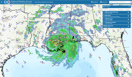
আমেরিকার আবহাওয়া পূর্বাভাষ বিষয়ক সংস্থা নোয়া এর Weather and Hazards Data Viewer for Decision Support and Situational Awareness. নামক ওয়েবসাইট থেকে নিয়ার রিয়েল টাইম ঘূর্ণিঝড় চিত্র, বিভিন্ন প্রকার ঝুঁকি মানচিত্র ও আবহাওয়া সম্পর্কিত বিভিন্ন ভ্যারিয়েবল এর মান একই মানচিত্রে দেখা যাবে। উল্লেখ্য যে এই সুবিধাটি শুধু মাত্র উত্তর আমেরিকার দেশগুলোর ক্ষেত্রে পাওয়া যাবে।
২৭) NRL/JPSS Next-Generation Weather Satellite (NexSat) সাইট হতে দক্ষিণ ও পূর্ব এশিয়ার দেশ গুলো ও অস্ট্রেলিয়ার ভিজিবল ইমেজারি পাওয়া যাবে।
এই সাইট হতে মডিস স্যাটেলাইটের টেরা ও একুয়া সেন্সর ও এনপিপি স্যাটেলাইটের ভিয়ার্স সেন্সর হতে সংগৃহীত ইমেজ থেকে ভিজিবল, নিয়ার ইনফ্রারেড, ট্রু-কালার, জ্বলীয়বাষ্প চিত্র সংগ্রহ করা যাবে।
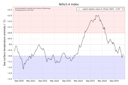
২৮) The El Niño Southern Oscillation (ENSO)
The El Niño Southern Oscillation (ENSO) phenomenon contributes significantly to seasonal climate fluctuations in many regions of the globe, often with social and economic implications for human populations and the environment. A monthly summary of the status of El Niño, La Niña, and the Southern Oscillation, or ENSO, based on the NINO3.4 index (120-170W, 5S-5N) is available from the following site: The El Niño Southern Oscillation (ENSO) Forecast
২৯) আমেরিকার University of Wisconsin-Madison বিশ্ববিদ্যালয়ের এর Cooperative Institute for Meteorological Satellite Studies কর্তৃক পরিচালিত এই সাইট হতে বিভিন্ন কৃত্রিম ভূ-উপগ্রহ থেকে প্রাপ্ত ছবি হতে পৃথিবীর বিভিন্ন স্হানের বায়ুমন্ডলের অবস্হা যেমন আকাশে মেঘের মপরিমান, ওয়াইল্ড ফায়ার, সমুদ্রের পানির তাপমাত্রা ইত্যাদির ইন্টারেক্টিভ ম্যাপ তৈরি করা যাবে। এই সাইটে কোন-কোন বিষয়ে তথ্য পাওয়া যাবে তার একটা লিস্ট পাওয়া যাবে এই সাইট থেকে RealEarth Product Inventory (Alphabetic list of available products)
৩০) আমেরিকার মহাকাশ গবেষণা প্রতিষ্ঠান নাসা এর ডাটা পোর্টাল Worldview থেকে প্রায় রিয়েল টাইম কৃত্রিম উপগ্রহ টেরা, একুয়া, ও সুওমি থেকে সংগৃহীত মেঘের চিত্র পাওয়া যাবে। কৃত্রিম উপগ্রহ থেকে প্রাপ্ত এই চিত্র ব্যবহার করে পৃথিবী পৃষ্ঠে অবস্থিত কোন স্থানের সম্ভব্য আবহাওয়ার পূর্বাভাষ করা যাবে আবহাওয়া সম্পর্কিত জ্ঞান ব্যবহার করে। এই চিত্র বিশেষ ভাবে কাজে লাগানো সম্ভব ঘূর্ণিঝড় এর জীবনচক্র পর্যবেক্ষণের জন্য। এই চিত্রে কিছু ডাটা গ্যাপ এলাকা থাকে কৃত্রিম উপগ্রহ গুলোর পাশাপাশি দুইটি ফ্লাইওভার এর মধ্যবর্তী এলাকার মধ্যে। তবে উপরে উল্লেখিত ৩ টি কৃত্রিম ভূ-উপগ্রহ হতে প্রাপ্ত চিত্রগুলো একত্রিত করলে নিরবচ্ছিন্ন ছবি পাওয়া সম্ভব। তবে এই কাজটা নিজকেই করতে হবে প্রয়োজন হলে।
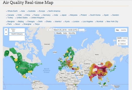
৩১) বায়ুদূষণ পরিমাপের জন্য যে সূচক ব্যবহার করা হয় তা হলো, প্রতি ঘনমিটারে পার্টিকুলেট ম্যাটারের পরিমাণ। এক ঘনমিটারের মধ্যে কত মাইক্রোগ্রাম পার্টিকুলেট ম্যাটার আছে। পার্টিকুলেট ম্যাটার হলো— বাতাসের মধ্যে ধূলিকণা, ময়লা, আবর্জনা, লতাপাতার ভগ্নাংশ, ফুলের রেণু ইত্যাদি। সাইজ অনুসারে পার্টিকুলেট ম্যাটারকে দুভাগে ভাগ করা হয়— ব্যাসার্ধ ২ দশমিক ৫ মাইক্রোমিটার (পিএম ২.৫) বা তার চেয়ে কম ও ১০ মাইক্রোমিটারের চেয়ে কম। ১ মাইক্রোমিটার হলো ১ মিটারের ১০ লক্ষ ভাগের এক ভাগ বা ১ মিলিমিটারের ১ হাজার ভাগের এক ভাগ। পার্টিকুলেট ম্যাটার দেখতে কত ক্ষুদ্র তা নিচের চত্রে মানুষের চুলের সাথে তুলনা করলেই বোঝা যায়। বিশ্ব স্বাস্থ্য সংস্থার মতে, গ্রহণযোগ্য ২ দশমিক ৫ মাইক্রোমিটার ব্যাসার্ধের পার্টিকুলেট ম্যাটারের পরিমাণ এক ঘনমিটারের মধ্যে সর্বোচ্চ ১০ মাইক্রোমিটার ও ১০ মাইক্রোমিটার দৈর্ঘ্যের পার্টিকুলেট ম্যাটারের পরিমাণ প্রতি ঘনমিটারের সর্বোচ্চ ২০ মাইক্রোগ্রাম। Air Quality Real-time Map সাইট থেকে পৃথিবী ব্যাপী ২ দশমিক ৫ মাইক্রোমিটার ব্যাসার্ধের পার্টিকুলেট ম্যাটারের এর পরিমান এর চিত্র দেখা যাবে।
রিয়েল টাইম বায়ুর গুনগত মান এর মানচিত্র পর্যবেক্ষন করা যাবে ইউরোমেটসেট এর ওয়েবসাইট থেকে। এই সাইট থেকেও ১০ মাইক্রোমিটার ও ১০ মাইক্রোমিটার দৈর্ঘ্যের পার্টিকুলেট ম্যাটারের ও নাইট্রজেনডাইঅক্সাইড এর তথ্য পাওয়া যাবে।
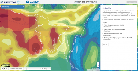
3-D Data Viewar
নিচের সাইট থেকে ঢাকা শহরের বায়ুর গুনমান জানা যাবে Dhaka air quality map: Live air pollution map of Dhaka
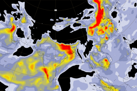
ইউরোপিয়ান ইউনিয়নের Copernicus Atmosphere Monitoring Service ওয়েবসাইট থেকে বায়ুর গুনগত মানের উপর বিভিন্ন তথ্য পাওয়া যায়। তাদের নিজের ভাষায় "We provide consistent and quality-controlled information related to air pollution and health, solar energy, greenhouse gases, and climate forcing, everywhere in the world." ১০ টি ভেরিয়েবলের উপর প্রতিদিনের পূর্বাভাষ পাওয়া যায় এই ওয়েবসাইট থেকে।
এই ১০ টি ভেরিয়েবল নিম্নরুপ: ১) Aerosol optical depth at 550 nm ২) Total column of carbon dioxide [ ppmv ] ৩) Total column of carbon monoxide [10^18 molecules / cm2] ৪) Total column of formaldehyde [10^15 molecules / cm2] ৫) Total column of methane [ ppbv ] ৬) Total column of nitrogen dioxide [10^15 molecules / cm2] ৭) Total column of ozone [DU] ৮) PM2.5 - fine particulate matter [ug / m3] ৯) Total column of sulphur dioxide [10^15 molecules / cm2] ১০) UV index (provided by CAMS)
Are you interested to know how polluted/clean the air of the city you are living?
There you go, "Beijing-based data scientist Yann Boquillod founded AirVisual Earth, an online air pollution map that uses data from satellites and more than 8000 monitoring stations to display global air pollution in real-time. The AirVisual Earth interactive maps (link enclosed below) prevailing wind patterns and shows color-coded concentrations of PM2.5—airborne particulate matter less than 2.5 microns in diameter that can penetrate deep into the lungs. Users can zoom in, tilt, and spin the globe for better viewing. The air pollution visualization was crafted “so people really understand how bad it is,” says Boquillod, who hopes an informed citizenry will pressure governments and communities to clear the air."
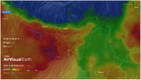
Source: Dennis Normile, Science Watch air pollution flow across the planet in real time
What is the MJO, and why do we care?
Madden-Julian Oscillation, or MJO Forecasts
Dynamical Model MJO Forecasts
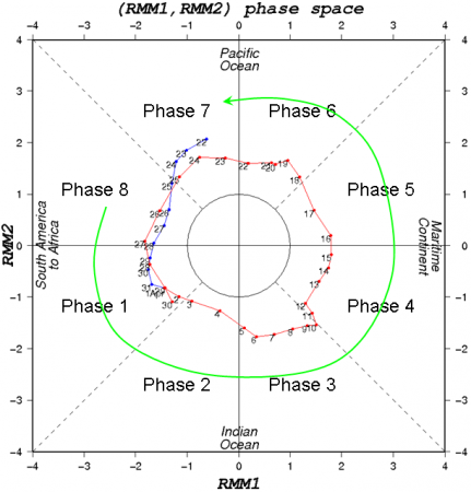
"Wheeler and Hendon (2004) divided the entire MJO cycle on the basis of the phase angle into eight phases. In these eight phases, phase 2 and 3 (P2 and P3) represent enhanced convection over the Indian Ocean, P4 and P5 represent enhanced convection over the Maritime Continent, P6 and P7 represent enhanced convection over the western Pacific Ocean, and P8 and P1 represent enhanced convection over the Western Hemisphere and Africa. They defined an active MJO day when the amplitude value was>1."
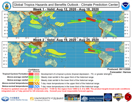
মেসন-জুলিয়ান দোলন এর প্রভাবে বিশ্বের বিভিন্ন স্থানের ট্রপিকাল এলাকায় আবহাওয়া কেমন হতে পারে পরবর্তী ২ সপ্তাহ তার পূর্বাভাষ পাওয়া যাবে ক্লাইমেট প্রেডিকশন সেন্টারের Global Tropics Hazards and Benefits Outlook Discussion ওয়েবসাইট থেকে।
The 35 Deadliest Tropical Cyclones in World History
REAL TIME INFORMATION ABOUT CYCLONE
Annual Tropical Cyclone Reports সাইট থেকে ১৯৫৯ সাল থেকে ২০১৬ সাল পর্যন্ত বিশ্বের বিভিন্ন প্রান্তে সংঘটিত সকল ঘূর্ণিঝড় এর তথ্য বর্ষ হিসাবে পিডিএড ডকুমেন্ট আকারে পাওয়া যাবে যা ঘূর্ণিঝড় গবেষণা ও এই বিষয়ে প্রবন্ধ লেখার জন্য গুরুত্বপূর্ণ সহায়ক তথ্য হিসাবে কাজে দিবে। Historical Hurricane Tracks সাইট থেকে পৃথিবীর বিভিন্ন প্রান্তে বিভিন্ন সময়ে সংগঠিত ঘুর্নিঝড় এর গতিপথ এর মানচিত্র পাওয়া যাবে। North Indian Ocean tropical cyclone database
ঘূর্ণিঝড় নিয়ে যদি আপনার কোন প্রশ্ন থাকে তবে আমাকে প্রশ্ন করতে পারেন। আমি চেষ্টা করবো উত্তর দিতে আমার সামর্থ্য অনুসারে। তমে আমি সকলকে অনুরোধ করবো নিম্নোক্ত সাইট ঘুরে আসতে। এই সাইটে ঘূর্ণিঝড় সম্বন্ধে প্রায় সকল সাধারণ প্রশ্নের উত্তর লিপিবদ্ধ করেছেন আমেরিকার আবহাওয়া পূর্বাভাষ গবেষণা প্রতিষ্ঠান নোয়া এর বৈজ্ঞানিক
Dr. Chris Landsea (currently at NOAA/National Hurricane Center) has put together a comprehensive Tropical Cyclone FAQ page, so please CHECK IT OUT... it will probably answer your initial question and any further questions about tropical cyclones that may think of!
This FAQ (Frequently Asked Questions) answers various questions regarding hurricanes, typhoons and tropical cyclones
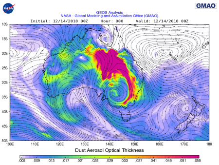
Global Modeling and Assimilation Office ওয়েবসাইট হতে নিয়ার-রিয়েল টাইম বিভিন্ন ধরনের Weather Analyses and Forecasts মানচিত্র পাওয়া যাবে। বিশেষ করে রেডিয়েন্স বা সূর্যের আলোর পরিমান, বায়ুমন্ডলে উপস্হিত বিভিন্ন গ্যাস (নাইট্রোজেনডাই অক্সাইড, ওজোন, মিথেন ইত্যাদি) ও প্রতি ৩ ঘন্টার মোট বৃষ্টিপাতের মানচিত্র পাওয়া যাবে। এই সাইটি পরিচালনা করে থাকে আমেরিকার মহাকাশ গবেষনা প্রতিষ্ঠান নাসা।
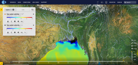
The European Space Agency (ESA) এর সেনটিনেল ৩ কৃত্রিম ভূ-উপগ্রহ হতে সমুদ্রের পানির রঙ NRT data visualization দেখে পানিতে উপস্হিত ক্লোরোফিল এর পরিমান সম্বন্ধে ধারণা পাওয়া যাবে। এছাড়াও European Space Agency (ESA) এর Ocean Virtual Laboratory ওয়েবসাইট হতে ESA পরিচালিত বিভিন্ন কৃত্রিম ভূ-উপগ্রহ হতে সংগৃহীত আবহাওয়া ও পরিবেশ সংক্রান্ত বিভিন্ন ভূ-চিত্র পাওয়া যাবে। এই সাইটি প্রায় নাসা পরিচালিত জিওভানি ওয়েবসাইট এর মতো। একই সাথে একটা ভেরিয়েবলের উপর অন্য ভেরিয়েবল এর ভূ-চিত্র ওভারল্যাপ করে কম্প্রিহেনসিভ মানচিত্র তৈরি করা যাবে। যেমন একই সাথে সমুদ্রের পানির তাপমাত্রা ও সমুদ্রের পানিতে উপস্থিত ক্লোরোফিল এর ঘনত্ব এর মানচিত্র একই সাথে তৈরি করা যাবে।
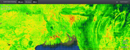
Earth Starts Beating ওয়েবসাই ইউরোপিয়ান ইউনিয়নের মহাকাশ গবেষনা প্রগ্রাম (The European Space Agency) এর Copernicus Sentinels missions এর বিভিন্ন কৃত্রিম ভূ-উপগ্রহ থেকে প্রাপ্ত পৃথিবী সম্পর্কিত বিভিন্ন তথ্য ব্যবহার করে পৃথিবীর বায়ুমন্ডল, জল ও স্হলভাগ সম্পর্কিত ৭ টি ভেরিয়েবলের তথ্যের টাইম সিরিজ তৈরি করাছেন যা নিম্নোক্ত ওয়েবসাইট থেকে সংগ্রহ করা যাবে। এই তথ্যগুলো দূর্যোগ ব্যবস্হাপনা ও পলিসি মেকিং এর জন্য খুবই উপকারি বলে মনে করি।
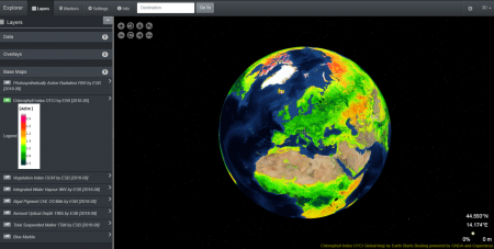
উপরে উল্লেখিত ৭ টি ভেরিয়েবল নিম্নরুপ:
১) OGVI (OLCI Global Vegetation Index): a fraction of absorbed photosynthetically active radiation (FAPAR) in the plant canopy. Dimensionless.
২) OTCI (OLCI Terrestrial Chlorophyll Index): it estimates of the chlorophyll content in terrestrial vegetation and aims at monitoring vegetation condition and health. Dimensionless.
৩) IWV (Integrated Water Vapour ): total amount of water vapour integrated over an atmosphere column. Expressed in kg*m-2.
৪) CHL: Chlorophyll-a concentration, computed using OC4Me algorithms. Measured in mg*m-3.
৫) TSM: Total suspended matter concentration. Expressed in g.m-3
৬) T865: Aerosol load, expressed in optical depth at a given wavelength (865 nm). Dimensionless.
৭) PAR (photosynthetically active radiation): Quantum energy flux from the sun in the spectral range 400-700 nm. Expressed in µEinstein.m-2. s-1
========================================================
দৈনন্দিন আবহাওয়া পূর্বাভাষ পাওয়া যাবে নিম্নোক্ত ওয়েবসাইগুলো থেকে।
========================================================
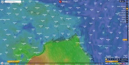
উইন্ডি ডট কম সাইট হতে আগামী ৭ দিনের আবহাওয়া পূর্বাভাষ পাওয়া যাবে।
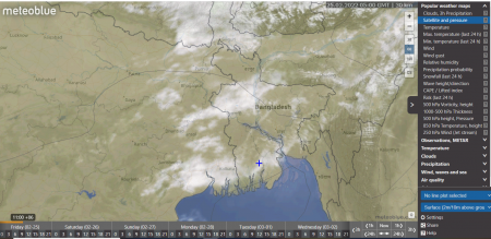
উইন্ডি ওয়েবসাইট এর মতো মেটিওব্লু নামক ওয়াবসাইটে (Meteoblue) আবহাওয়া বিষয়ক বিভিন্ন সূচক একই ইন্টারফেসে দেখা যাবে।
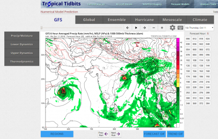
ট্রপিকাল টিডবিট সাইট থেকে বেশি কিছু আবহাওয়া পূর্বাভাষ মডেল অনুসারে আবহাওয়া পূর্বাভাষ পাওয়া যাবে ১ থেকে ৭ দিন পর্যন্ত সময় ভেদে প্রতি ৬ ঘন্টা থেকে ১ দিন অন্তর। ট্রপিকাল টিডবিট সাইট থেকে আবহাওয়া সম্পরর্কিত অনেকগুলো ভেরিয়েবল সম্বন্ধে তথ্য পাওয়া যাবে।
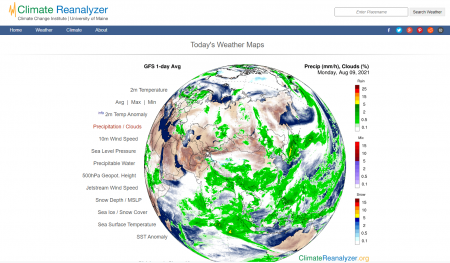
আমেরিকার মাইন বিশ্ববিদ্যালয়ের ক্লাইমেট এনালাইজার ওয়েবসাইট থেকে প্রতিদিনকার বিশ্বের বিভিন্ন প্রান্তের আবহাওয়ার পূর্বাভাষ মানচিত্র পাওয়া যাবে একটিমাত্র চিত্রের মাধ্যমে। এই সাইটির মূল শক্তি হলও পেজ ন্যাভিগেশনের ঝামেলা নাই বললেই চলে। শুধুমাত্র মাউস বাম পাশের প্যানেল থেকে সিলেক্ট করলেই সংশ্ষিলষ্ট বিষয়ের চিত্র চলে আসবে স্ক্রিনে।
Today's Weather Maps
Bangladesh Weather Map
ওয়েদার অনলাইন নামক ওয়েবসাইট থেকে বাংলাদেশের বিভিন্ন শহরের দৈনন্দিন ও প্রতি ৩ ঘন্টা অন্তর-অন্তর আবহাওয়া সম্পর্কিত বিভিন্ন তথ্য (তাপমাত্রা, বৃষ্টিপাত ইত্যাদির তথ্য) পাওয়া যাবে।
========================================================
মৌসুমি আবহাওয়া পূর্বাভাষ পাওয়া যাবে নিম্নোক্ত ওয়েবসাইট থেকে।
========================================================
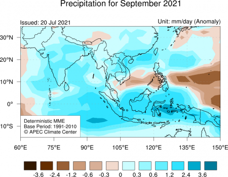
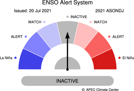
দক্ষিণ কোরিয়ার APEC Climate Center এর Climate Information Services এর ওয়েবসাইট থেকে নিম্নে বর্ণিত বেশ কয়েকটি সুবিধা পাওয়া যাবে:
১) বৃষ্টিপাত ও তাপমাত্রার মাসিক ও ত্রি-মাসিক (সিজনাল) পূর্বাভাষ মানচিত্র
২) আবহাওয়া ও জলবায়ু বিষয়ক বিভিন্ন ইনডেক্স (Climate Indices): ENSO, IOD, MJO, ইত্যাদি
৩) ১৯৯১ সাল থেকে ২০২১ সাল পর্যন্ত ভূ-পৃষ্ঠ থেকে ২ মিটার ও ১০ মিটার উচ্চতায় বায়ুমণ্ডলের তাপমাত্রা, সমুদ্র পৃষ্ঠের তাপমাত্রা, বৃষ্টিপাতের চিত্র, ৫০০ মিলিবার বায়ুচাপ এর জিওপোটেনশিয়াল উচ্চতা, ও পৃথবির বায়ুমণ্ডল থেকে মহাশুন্যগামী বিকিরণ (Outgoing Longwave Radiation) এর মানচিত্র
=========================================================================
এল নিনো (El Niño), লা-নিনা ( La Niña,) ও সাউদার্ন ওছিলেনশন (Southern Oscillation) এর চলমান অবস্হা
=========================================================================
আবহাওয়া ও জলবায়ু বিষয়ক বিভিন্ন সূচক (ENSO, IOD, MJO, ইত্যাদি) যেগুলো দৈনন্দিন থেকে মৌসুমি আবহাওয়া নির্দেশক হিসাবে প্রভাব বিস্তার করে এই রকম সূচক গুলোর সাপ্তাহিক আপডেট পাওয়া যাবে অস্ট্রেলিয়ান আবহাওয়া অধিদপ্তর থেকে (Climate drivers in the Pacific, Indian and Southern oceans and the Tropics)
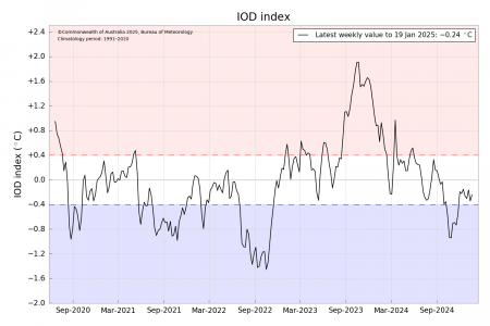
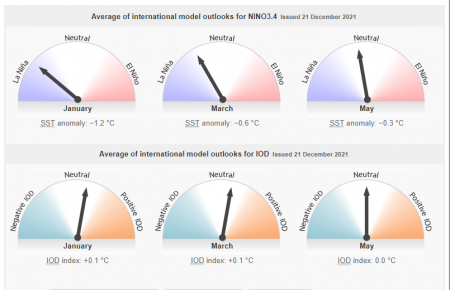
আমেরিকার কলম্বিয়া বিশ্ববিদ্যালয়ের International Research Institute for Climate and Society প্রতিমাসের এল নিনো (El Niño), লা-নিনা ( La Niña,) ও সাউদার্ন ওছিলেনশন (Southern Oscillation) এর ওয়েবসাইট IRI ENSO Forecast থেকে মাসিক আপডেট পাওয়া যায়।
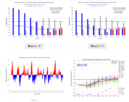
এছাড়া, আমেরিকার আবহাওয়া পূর্বাভাষ সংস্হা The National Weather Service প্রতিমাস এল নিনো (El Niño), লা-নিনা ( La Niña,) ও সাউদার্ন ওছিলেনশন (Southern Oscillation) এর একটি আলোচনা প্রদান করেন।
ইউরোপিয়ান ইউনিয়নের কোপার্নিকাস প্রগ্রামের অধিনে ৪ মাস পর্যন্ত অগ্রিম বন্যা পূর্বাভাষ পাওয়া যাবে নিম্নোক্ত ওয়েবসাইট থেকে।
GloFAS seasonal outlook provides forecasts of unusually high or low river flow up to four months ahead
******************************** সমুদ্র পৃষ্ঠের পানির তাপমাত্রা ********************************
সমুদ্র পৃষ্ঠের পানির তাপমাত্রা আবহাওয়া ও জলবায়ু পূর্বাভাষের একটি অন্যতম গুরুত্বপূর্ণ নির্দেশক হিসাবে গণ্য করা হয়ে থাকে। বিশেষ করে ঘূর্ণিঝড় ও হ্যারিকেন সৃষ্টি হওয়ার সম্ভাবনা নির্দেশ করা যায় সমুদ্র পৃষ্ঠের পানির তাপমাত্রা দেখে। ঘূর্ণিঝড় ও হ্যারিকেন সৃষ্টি হওয়ার জন্য প্রধানতম শর্ত হলও সমুদ্র পৃষ্ঠের পানির তাপমাত্রা অবশ্যই ২৬ দশমিক ৫ ডিগ্রী সেন্টিগ্রেড বা তার চেয়ে বেশি। নিম্নোক্ত ওয়েবসাইট থেকে সমুদ্র পৃষ্ঠের পানির দৈনন্দিন তাপমাত্রা পাওয়া যাবে। এই ওয়েবসাইটটি আমেরিকার মহাকাশ গবেষণা সংস্থা নাসা কর্তৃক পরিচালিত।
Sea Surface Temperature data from the Multi-Scale Ultra-High Resolution (MUR) dataset
Operational SST Anomaly Charts for 2019
NOAA Coral Reef Watch Operational 5km SST Anomaly Charts
IPCC 6th Assessment Report Sea Level Projections
Optimum Interpolation Sea Surface Temperature Anomaly for North Indian Ocean সমুদ্রের পানির তাপমাত্রার বিচ্যুতি মানচিত্র
ইউরোপিয়ান ইউনিয়ন কর্তৃক পরিচালিত WekEO ওয়েবসাইট থেকে Copernicus and Sentinel প্রোগ্রাম এর অন্তর্গত সকল কৃত্রিম ভূ-উপগ্রহ থেকে প্রাপ্ত প্রায় দৈনন্দিন তথ্য পাওয়া যাবে। এই সাইটিকে আমেরিকান মহাকাশ গবেষণা সংস্থা কর্তৃক পরিচালিত ওয়েবসাইটের যমজ ভাই বলা যাবে।
**************************************************************************************************
******* নির্দিষ্ট স্হানের আবহাওয়া সম্পর্কে তথ্য পাওয়া যায় মেটিওগ্রাম নামক একটি মানচিত্র থেকে *******
**************************************************************************************************
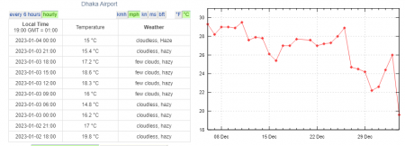
কোন নির্দিষ্ট স্হানের আবহাওয়া কেমন তা সম্পর্কে তথ্য পাওয়া যায় মেটিওগ্রাম নামক একটি মানচিত্র থেকে। এই মানচিত্রে কোন স্হানের দৈনন্দিন আবহাওয়া সম্পর্কিত নিম্নোক্ত তথ্য গুলো পাওয়া যায়: তাপমাত্রা (ভূ-পৃষ্ট হতে বিভিন্ন উচ্চতায়), ডিউ পয়েন্ট তাপমাত্রা, বায়ুর গতিবেগ, বাতেসে জ্বলীয় বাষ্পের পরিমান, সমুদ্র পৃষ্ঠে বায়ু চাপ, আকাশে মেঘের পরিমান, বৃষ্টিপাতের পরিমান, বৃষ্টিপাতের প্রকারভেদ (বৃষ্টি, স্নো, ফ্রিজিং রেইন), বর্জ্র বৃষ্টির সম্ভাবনা পরিমাপক সূচক যেমন কেপ, লিফটেড ইন্ডেক্স ইত্যাদি।
"A meteogram is a graphic showing the evolution in time of meteorological data at a fixed location. Several variables are plotted in a meteogram as line graphs, bar graphs, symbols, numbers, or shaded contours. A meteogram illustrates how the variables relate to one another as weather conditions evolve."
আমেরিকার জর্জ-মেসন বিশ্ববিদ্যালয় Weather and Climate Data নামক একটি ওয়েবসাইট পরিচালনা করেন যে সাইট থেকে কাস্টমাইজড (নিজের ইচ্ছে মতো স্হানের) মেটিওগ্রাম মানচিত্র তৈরি করে নেওয়া যাবে। মেটিওগ্রাম মানচিত্রে উল্লেখিত ভেরিয়েবল গুলো সম্বন্ধে বিস্তারিত তথ্য জানার আগ্রহ থাকলে Guide to the Meteograms থেকে জেনে নিতে পারবেন।
ল্যাটিটিউড নামক এই ওয়েবসাইট থেকে আপনার জেলার অক্ষাংশ ও দ্রাঘিমাংশ এর মান নিয়ে তা জর্জ মেসন বিশ্ববিদ্যালয় প্রদত্ত সাইটে প্রদান করলে ঐ সাইট আপনার প্রদত্ত স্হানের আগামী ৭ দিনের মেটিওগ্রাম তৈরি করে দিবে যা থেকে আপনি আপনার স্হানের আব হাওয়া সম্পর্কীত পূর্বাভাষ পেতে পারেন। মনে রাখবেন আপনি শুধু কোন পূর্ন সংখ্যা ও সংখ্যার অর্ধেক মান দিতে পারবেন ঐ সাইটে। উদাহারণ স্বরুপ আমার নিজের জেলা নীলফামারী এর অক্ষাংশ ও দ্রাঘিমাংশ এর মান হলো যথাক্রমে 25.8483° N, 88.9414° E। ফলে আমি কাছা-কাছি পূর্ন সংখ্যা ২৬ ও ৮৯ ব্যবহার করেছি অক্ষাংশ ও দ্রাঘিমাংশ এর মান হিসাবে।
**************************************************************************************************
************************* আবহাওয়ার পূর্বাভাষে রাডার প্রযুক্তির ব্যবহার *************************
**************************************************************************************************
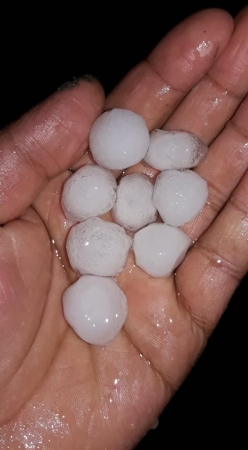
আবহাওয়া রাডার ব্যবহার করে বৃষ্টিপাতের পরিমান, কালবৈশাখি ঝড় এর কারণে শীলা বৃষ্টি হওয়ার সম্ভাবনা ও ঘুর্নিঝড় প্রবাহের দিক নির্দেশ নির্নয় করা যায়। নিম্নে সংযুক্ত ছবিটি বাংলাদেশ বিমান বাহিনীর রাডার হতে প্রাপ্ত।
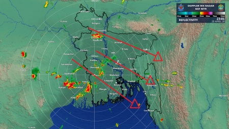
রাডার হতে প্রাপ্ত ছবির কালার বর্ণনা: রাডার হতে নির্গত আলোক শক্তি বৃষ্টির পানি কিংবা জ্বলীয় বাষ্পের কণা হতে প্রতিফলিত হয়ে রাডারের রিসিভারে ফেরত আসে। ফেরত আসা প্রতিফলিত শক্তি লগারিদমিক স্কেলে পরিমাপ করা হয়। প্রতিফলিত শক্তি পরিমাপের একক হচ্ছে dBZ (ডেসিবল. প্রতিফলিত শক্তি যদি ২০ ডেসিবল নিচে থাকে তাহলে স্বল্প বা গুড়ি-গুড়ি বৃষ্টিপাত হয়। রিফ্লেকটিভিটি ও বৃষ্টিপাতের হার এর একটি গানিতিক সম্পর্ক আছে যা ব্যব হার করে বৃষ্টিপাতের পরিমান নির্নয় করা হয়। মেঘের মধ্যে জ্বলীয় বাষ্পের পরিমান বা বৃষ্টিপাতের পরিমান যত বেশি হবে রিফ্লেকটিভিটি এর মান তত বেশি হবে। প্রতিফলিত শক্তি ২০ থেকে ৩৫ ডেসিবলের মধ্যে থাকলে মাজারি মানের বৃষ্টি ও ৩৫ ডেসিবলের উপরে হলে ভারি বৃষ্টিপাত নির্দেশ করে।
[The colors on the legend are the different echo intensities (reflectivity) measured in dBZ. "Reflectivity" is the amount of transmitted power returned to the radar receiver. The scale of dBZ values is also related to the intensity of rainfall. Typically, light rain is occurring when the dBZ value reaches 20. The higher the dBZ, the stronger the rainrate.]
বাংলাদেশ বিমান বাহিনীর ওয়েবসাইট থেকে রিয়েল টাইম রাডার চিত্রে বাংলাদেশের আকাশে বৃষ্টিপাতের চিত্র পাওয়া যাবে।
Thunderstorm Observation, Prediction and Monitoring (STORM) by Indian Meteorological Department
Radar Animation by Indian Meteorological Department
Weather and Radar
কালবৈশাখী ঝড়ের কারণে শিলাবৃষ্টি হওয়ার সম্ভাবনা পূর্বাভাষ করা হয় কিভাবে?
রাডার থেকে প্রাপ্ত চিত্র দেখে কালবৈশাখী ঝড়ের কারণে শিলাবৃষ্টি হওয়ার সম্ভাবনা পূর্বাভাষ করা যায়। রাডার হতে প্রাপ্ত ছবিতে যখন রিফলেকটিভিটি এর মান ৫০-৬০ এর বেশি নির্দেশ করে যে স্থানে সেখানে শিলা বৃষ্টি হওয়ার সম্ভাবনা প্রবল। নিচে রাডার হতে প্রাপ্ত চিত্রে বৃত্ত চিহ্নিত স্হাটির উপর রিফলেকটিভিটির মান লক্ষ করুন।
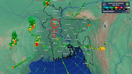
নিচে শিলার (রাত ১ টার দিকে এই শিলা বৃষ্টি হয়েছে) যে ছবিটি যোগ করা হয়েছে তা বগুড়া জেলা সদর উপজেলা মাটিডালি এলাকা হতে প্রাপ্ত। ছবিটি ফেবুকে শেয়ার করেছেন বগুড়ার অধিবাসী Ãbü Sähåd Sïãm নামক এক ব্যক্তি।
**************************************************************************************************
************************* বর্জ্রপাত, শিলা বৃষ্টি, ও টর্নেডোর সম্ভাব্যতা পূর্বাভাষ *************************
**************************************************************************************************
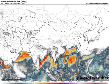
বর্জ্রপাত, শিলা বৃষ্টি, ও টর্নেডোর সম্ভাব্যতা পূর্বাভাষের জন্য আবহাওয়া সম্পর্কিত তিনটি ভেরিয়েবল Convective Available Potential Energy (CAPE), Lifted Index (LI), Storm Relative Helicity ব্যবহার করা হয়ে থাকে। ওয়েদার অনলাইন নামক ওয়েবসাইট থেকে এই দুইটি ভেরিয়েবল সম্বন্ধে প্রায় রিয়েল টাইম তথ্য পাওয়া যাবে।
Convective Available Potential Energy (CAPE) is a measure of the amount of energy available for convection. CAPE is directly related to the maximum potential vertical speed within an updraft; thus, higher values indicate a greater potential for severe weather.
Observed values in thunderstorm environments often may exceed 1,000 joules per kilogram (j/kg), and in extreme cases may exceed 5,000 j/kg. However, as with other indices or indicators, there are no threshold values above which severe weather becomes imminent. CAPE is represented on a sounding diagram by the area enclosed between the environmental temperature profile and the path of a rising air parcel, over the layer within which the latter is warmer than the former. (This area often is called positive area). However, when estimating thunderstorm probability one should also always have a look at the Lifted Index.
Pivotal Weather offers Freely available fast quality numerical weather prediction model images from the Euro, GFS, HRRR, NAM, 3km NAM, and more.
Thunderstorm Probability
The Lifted Index is a measure of the atmosphere's stability (or instability) and Meteorologists use it to determine the thunderstorm potential. It doesn't accurately predict the intensity of every single storm, but it is a useful tool to estimate the atmosphere's potential to produce severe thunderstorms.
Chance of thunderstorm
picture "Parcels" (or bubbles) of air start to rise on their own if they are warmer than the surrounding air. This process is called convection. Consider an air parcel as it begins to rise through the atmosphere after being heated by the sun and the warming ground. The Lifted Index is defined as a rising parcel's temperature when it reaches the 500 millibars level (at about 5,500m or 18,000 feet asl), subtracted from the actual temperature of the environmental air at 500 millibars. If the Lifted Iindex is a large negative number, then the parcel will be much warmer than its surroundings, and will continue to rise. Thunderstorms are fueled by strong rising air, thus the Lifted Index is a good measurement of the atmosphere's potential to produce severe thunderstorms.
The following site can be used to see the current state of LI over Bangladesh and its surrounding counties. The Lifted Index (LI)
Lifted Index value more than 11> Extremely stable conditions > Thunderstorms unlikely
8 to 11 > Very stable conditions > Thunderstorms unlikely
4 to 7 > Stable conditions > Thunderstorms unlikely
0 to 3 > Mostly stable conditions > Thunderstorm unlikely
-3 to -1> Slightly unstable > Thunderstorms possible
-5 to -4 > Unstable > Thunderstorms probable
-7 to -6 > Highly unstable > Severe thunderstorms possible
less than -7 > Extremely unstable > Violent thunderstorms, tornadoes possible
For example, if the rising parcel has a temperature of -5°C when it reaches 500 millibars, but the actual temperature at 500 millibars is -11°C, then the lifted index is -6 Kelvin (or K) indicating the potential for strong thunderstorms. However, there are no specific threshold values that correlate lifted index to thunderstorm severity. In general, a negative Lifted Index indicates an unstable atmosphere, so the larger the negative number, the more unstable the atmosphere is, the stronger a thunderstorm could be. Lifted index values rarely go below -7.
Important ! The Lifted Index is not a measured quantity, it is only a parameter that is theoretically derived. If the Lifted Index is favorable for severe storms but other conditions are not met, then no storms may form at all.
Storm Relative Helicity (m2 s-2) Storm Relative Helicity (m2 s-2)
SRH (Storm Relative Helicity) is a measure of the potential for cyclonic updraft rotation in right-moving supercells, and is calculated for the lowest 1-km and 3-km layers above ground level. There is no clear threshold value for SRH when forecasting supercells, since the formation of supercells appears to be related more strongly to the deeper layer vertical shear. Larger values of 0-3-km SRH (greater than 250 m2 s-2) and 0-1-km SRH (greater than 100 m2 s-2), however, do suggest an increased threat of tornadoes with supercells. For SRH, larger values are generally better, but there are no clear thresholds between non-tornadic and significant tornadic supercells.
ইউরোপিয়ান The European Centre for Medium-Range Weather Forecasts মডেল থেকে K-Index, Total-Total Index, and CAPE এর মানচিত্র পাওয়া যাবে।
নিম্নোক্ত সাইট থেকে বর্জ্রপাত সংঘটিত হওয়ার স্হান ও সময় এর মানচিত্র প্রকাশ করা হয়ে থাকে যা দেখে সাম্ভব্য ঝড় এর পূর্বাভাষ করা যায়। Lightning detection Bangladesh
ECMWF model charts থেকে আরও কিছু আবহাওয়া সম্পর্কিত ভেরিয়েবল এর মানচিত্র দেখা যাবে যে মানচিত্রগুলো বাংলাদেশের উপর কাস্টমাইজ করা যাবে। এই ভেরিয়েবলগুলো বিশ্লেষন করে বাংলাদেশের আবহাওয়া সম্পর্কে আরও স্পষ্ট ধারণা পাওয়া যাবে।
ঢাকা শহরের সর্বশেষ সাউন্ডিং ডাটা
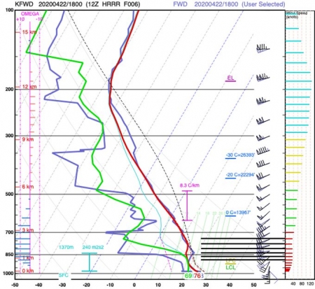
University of wyoming এর Department of Atmospheric Science এর ডাটা সার্ভার থেকে বিশ্বে বিভিন্ন স্হানের সাউন্ডিং ডাটা ডাউনলোড করা যায় ও সর্বশেষ সাউন্ডিং ডাটা দেখে কোন স্হানের তৎকালীন আব হারওয়ার অবস্হা সম্বন্ধে জানা যায়। এই ডাটা বেশিভাগ ক্ষেত্রে কাজে লাগে কোন স্হানে কালবৈশাখি ঝড় হওয়ার সম্ভাবনা নিরুপন করার জন্য।
WMO-Station ID; StationName; Latitude; Longitude; Height; Country
RAOB Data Sources
Sounding Products
======================
জেট স্ট্রিম পূর্বাভাষ মানচিত্র
======================
জেট স্ট্রিম পূর্বাভাষ
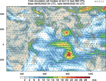
জার্মানির হামবুর্গ বিশ্ববিদ্যালয়ের আবহাওয়া বিজ্ঞান ইন্সটিটিউট এর ওয়েবসাইট থেকে বায়ুমণ্ডলের বিভিন্ন উচ্চতায় বায়ুর গতি ও আবহাওয়া সম্পর্কিত বিভিন্ন দোলন
Modal view of atmospheric circulation এর বর্তমান অবস্থা ও পূর্বাভাষ মানচিত্র পাওয়া যাবে।
=======================
Upper Air Charts
=======================
By convention world-wide, constant pressure charts are typically created for the 200 mb, 300 mb, 500 mb, 700 mb and 850 mb pressure levels. Together, these five levels give the meteorologist a good representation of the state of the atmosphere.
Introduction to Upper-Air Charts
নিম্নোক্ত ওয়েবসাইটে পৃথিবীর উল্লেখযোগ্য সংখ্যাক আবহাওয়া ও জলবায়ু বিষয়ক গুরুত্বপূর্ন ওয়েবসাইটের তথ্য পাওয়া যাবে।
Track The Tropics Website
আশা করছি উপরের ২ ডজন ওয়েবসাইট হতে তথ্য সংগ্রহ করে নিজেদের জীবন ও সম্পদের রক্ষা করতে পারবেন অন্যের উপর নির্ভর না করে। সেই সাথে বাংলাদেশের সংবাদ মাধ্যমের কর্মী, বিভিন্ন স্বেচ্ছাসেবক প্রতিষ্ঠান, দাতব্য প্রতিষ্ঠান, ও ত্রাণ বিতরণের সাথে জড়িত সরকারি প্রতিষ্ঠানের সাথে জড়িত মানুষরা নিজেদের প্রফেশনাল কাজে লাগাতে পারবেন।
=================================
মোস্তফা কামাল পলাশ
আবহাওয়া ও জলবায়ু গবেষক
সাসকাটুন, সাস্কাচয়ান, কানাডা
E-mail: [email protected]
**************************************************
সর্বশেষ এডিট : ২৩ শে জানুয়ারি, ২০২৫ দুপুর ১২:১৪